|
Table of Contents - Click on location links to go to information
Introduction. 11
To Flows. 11
To Impaired Water Bodies 12
To Spills. 12
To HABs. 13
Sources: 13
Central NY Watersheds 13
Upper Hudson River Watershed. 13
Flows parts of Essex, Hamilton, Saratoga, Washington, Rensselaer and Warren Counties 13
Impaired Water Bodies (26) 15
HABs (0) 15
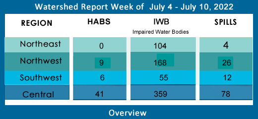
Spills (4) 15
Saratoga County: 15
Washington County: 16
Mohawk River Watershed. 16
Flows draining parts of Schenectady, Oneida, Herkimer, Montgomery, and Albany Counties 16
Impaired Water Bodies (28) 19
HABs (2) 20
Spills (6) 20
Fulton County: 20
Oneida County: 20
Schenectady County: 20
Lower Hudson River Watershed –. 20
Flows catching parts of Albany, Rensselaer, Dutchess, Columbia, Ulster Counties 21
Impaired Water Bodies (80) 25
Hazardous Algae Blooms - HABs (17) 25
Spills (23) 27
Westchester County: 27
Putnam County. 28
Columbia County: 28
Albany: 28
Orange County: 29
Rensselaer County: 29
Delaware River Watershed. 29
Flows streaming over parts of Delaware, Ulster, Sullivan Counties. 29
Impaired Water Bodies (25) 32
Hazardous Algae Blooms HABs (1) 32
Spills (9) 33
Sullivan County: 33
Ulster County. 33
Housatonic River Watershed. 33
Flows: parts of Dutchess County. 33
Impaired Water Bodies (0) 34
Hazardous Algae Blooms – HABs (1) 34
Spills (2) 34
Dutchess County: 34
Orange County: 34
Atlantic Ocean/Long Island Sound Watershed. 34
Flows taking in run-off from parts of Bronx, Queens, Kings, Suffolk, Nassau and New York Counties 35
Impaired Water Bodies (200) 36
Hazardous Algae Blooms - HABs (20) 36
Spills (35) 38
Westchester County: 38
New York County (Manhattan): 39
Kings County (Brooklyn): 39
Queens County: 39
Nassau County: 40
Suffolk County: 40
Richmond County: 41
Bronx County: 41
Northeast Watersheds 41
Lake Champlain Watershed. 41
Flows. 41
Impaired Water Bodies (29) 42
HABs (0) 42
Spills (2) 42
Clinton County: 42
Essex County: 43
St. Lawrence River Watershed. 43
Flows: parts of St. Lawrence and Franklin Counties 43
Spills (1) 44
St. Lawrence County: 44
Black River Watershed. 44
Flows: Filters and drains most of Jefferson and Lewis Counties along with parts of Herkimer, Hamilton, and Oneida Counties. 45
Impaired Water Bodies (34) 45
Spills (1) 45
Jefferson County. 45
Northwest Watersheds 45
Lake Ontario and Minor Tributaries 45
Flows considering most of Jefferson and Orleans Counties, parts of Monroe, Oswego, Wayne and Niagara Counties. 46
Impaired Water Bodies (56) 47
HABs (2) 47
Spills (3) 47
Niagara County: 47
Monroe County: 47
Niagara River/Lake Erie Watershed. 47
Flows: parts of Niagara, Wyoming and Erie Counties. 48
Impaired Water Bodies (49) 49
HABs (0) 49
Spills (7) 49
Erie County: 49
Niagara County: 49
Genesee River Watershed. 49
Flows parts of Monroe, Livingston, and Allegany Counties. 50
Impaired Water Bodies (23) 51
Hazardous Algae Blooms – HABs (5) 51
Spills (10) 52
Livingston County. 52
Monroe County. 52
Wyoming County. 53
Oswego River and Finger Lakes Watershed. 53
Flows draining parts of Oswego, Madison, Cayuga, Tompkins, Seneca, Onondaga, Yates and Ontario Counties. 53
Impaired Water Bodies. 55
HABs (2) 56
Spills (6) 56
Onondaga County: 56
Tompkins County: 56
Oneida County: 56
Oswego County: 56
Southwest Watersheds 56
Allegheny River Watershed. 56
Flows taking in parts of Chautauqua and Cattaraugus County. 57
Impaired Water Bodies (14) 57
HABs (3) 57
Spills (3) 58
Chautauqua County. 58
Chemung River Watershed. 58
Flows: washing over parts of Steuben and Chemung Counties 58
Impaired Water Bodies (9) 59
HABs (2) 60
Spills (3) 60
Chemung County: 60
Steuben County: 60
Susquehanna River Watershed. 60
Flows parts of Otsego, Broome, Chenango and Cortland Counties 60
Impaired Water Bodies (18) 62
Hazardous Algae Blooms (HABs) 62
Bradley Brook Reservoir June 29, 2022, report submitted to NYHABS by CSLAP 62
Spills (2) 62
Broome County: 62
Ramapo River Watershed. 62
Flows. 63
Impaired Water Bodies (14) 63
HABs (0) 63
Spills (4) 63
Rockland County: 63
Report Key: 64
Introduction
To Flows
WTNY describes the stream flows in each of NYS 17 watersheds, including direction/path of flow, listing 1200 monitoring stations in order from headwaters to outlet, including a flow rating (where available), flow volume in cubic feet per second (CFS), the depth of flow in feet and inches, the water temperature and specific conductance (where this information is available). WTNY logs a snapshot of the stream flows through the state’s rivers and tributaries once a month, as per USGS Waterwatch current streamflow monitoring stations.
- Rivers, and creeks flowing much above normal or high (in the top 10% of flow volume recorded for that system) are shown in boldface;
- flows that have breached action stage appear in red,
- flows in flood stage appear in boldface red type.
- Ice-affected flows are shown in italics.
Flow volume can change rapidly during snowmelt and rain events. All readings are posted as they appear as of our monthly update.
During melting and rain events, check your local upstream station flow levels at the USGS WaterWatch Current Streamflow site or sign up for high flow alerts. Streamflow data is subject to review as sensors at the monitoring stations do malfunction from time to time. See USGS Provisional Data Statement at the end of this report for more information.
To Impaired Water Bodies
The EPA requires all states update a draft list of impaired water bodies (the 303d list) every two years; providing a period for public comments, presenting the draft list to the EPA. The final 303d list is published as approved by the EPA, roughly every two years.
Impaired water bodies are defined as with contaminants measured above threshold levels set by the EPA Clean Water Act, or where the desired use is impaired. The latest Draft List for New York State, covering 2020-2022 has closed for public comments, being submitted to EPA for review. (See the 2020-2022 Draft Impaired Water Bodies 303(d) List, organized by watershed area, here on this site.) The 2020-2022 Draft list includes NYS lakes, creeks, rivers and reservoirs that New York Department of Environmental Conservation has recommended for de-listing, along with water bodies requiring Total Maximum Daily Load (TMDL) plans. The TMDL plan is a type of Clean Water Plans, established by a collaboration of municipal, industrial and environmental groups in an overlay zoning district.
To Spills
Reporting from the latest records uploaded to the NYS Hazardous Spill Incidents database by County each week. Spills are included in the relevant in watershed section, with location of the spill, the contaminant spilled (if known), the quantity (if known) and the resource affected (if known) surface water, groundwater, sewer, etc). The DEC receives over ten thousand spill reports each year; WTNY lists the spills over 10 gallons, spills of unknown amounts, spills of very toxic substances or substances that enter the water, regardless of the amount.
To HABs
Hazardous algae blooms are reported here as they are confirmed across the state, as found on the NYS Department of Environmental Conservation NYHABs notification site. Confirmed HABs are listed by watershed with a description of the location on the water body, limited by the accuracy of the location tag in the report. Contact parks management for more information on local conditions before heading out and consider using an on-site rapid test for cyano-toxin.
Sources:
WaterToday New York aggregates information and data from New York State Department of Environmental Conservation, Department of Health, Region 2- EPA, USGS, NWS, NOAA by watershed area. The accuracy of the information contained in our reports is dependent on these sources. Provisional data statements apply, confirm data with local authorities before taking action.
Central NY Watersheds
emptying into Atlantic Ocean at Long Island Sound
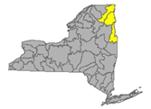
Upper Hudson River Watershed
The Upper Hudson River Watershed drains the south side of the Adirondack Mountains, originating on Mt. Marcy and flowing south; the watershed management area extends to the Albany-Rensselaer County line. From the confluence of the Mohawk River, the Lower Hudson River gathers volume and carries on south to the Atlantic via Long Island Sound tidal estuary.
Including Sacandaga River, Schroon River, Indian River, Fish Creek, Hoosic River, Batten Kill, Great Sacandaga Lake, Indian Lake, Schroon Lake, Saratoga Lake
Flows parts of Essex, Hamilton, Saratoga, Washington, Rensselaer and Warren Counties
- Upper Hudson River drains an area of 8288 sq miles from headwaters to Albany; flow
- at Newcomb in Essex County is normal, 56.7% above mean at 168 cfs and down a foot, 1.94 ft deep (flood stage 12.5 ft);
- at North Creek in Warren County is normal, 104.8% above mean up to 1210 cfs, and up half a foot, 3.78 ft deep (flood stage 10ft);
- at Hadley flow is below normal, 45.8% above mean, less than half the volume of two weeks ago, 1000 cfs and down a few inches, 2.41 ft deep (flood stage 14 ft);
- at Fort Edward in Washington County is below normal: 42.3% above mean and cut in volume again this week, from over 3000 cfs to 1820 cfs; and down to 20.7 ft deep (flood stage 26 ft);
- at Thomson in Washington County is unrated, 39.85% above mean at two-thirds last week’s volume, 2090 cfs and down to 20 ft deep;
- above Lock 1 near Waterford is flowing much below normal, 42.5% above mean at 2540 cfs and 30.01 ft deep (flood stage 34 ft). (flow information updated 06-23-22)
- Hudson River 303d listed for iron, aluminum and total phenols, copper, pH, listed in 1998 for PCBs, mercury, recommended for delisting in 2022 due to flawed original analysis
- Vanderwhacker Brook Trib 2 drains an area of .35 sq miles in Essex County before entering the Boreas River system. There are no active monitors on the Boreas, which runs through Essex County, and joins the Hudson system. Vanderwhacker Brook is unrated, 42.3% above mean at .11 cfs and .55 ft deep (06-23-22)
- Durgin Brook drains an area of 6.86 sq miles of Essex County before entering the Boreas River system. Flow at Boreas River is unrated, 50.9% above mean flow at 4.76 cfs and 1.98 ft deep, 12.2º (06-23-22)
- Indian River drains an area of 132 sq miles in Hamilton County. The flow near Indian Lake is rated normal at 60.5% above mean flow at 167 cfs and 1.81 ft deep. (06-23-22)
- Schroon River drains an area of 527 sq miles in Warren County; the flow at Riverbank is not rated, registers 2.04 ft deep (flood stage 7ft) (updated 06-23-22)
- Glens Falls Feeder (canal) in Washington County at Dunham Basin is unrated, 30.2% above mean at 30.4 cfs and 2.93 ft deep. (updated 06-23-22)
- Sacandaga River drains an area of 1055 sq miles in Hamilton and Saratoga Counties. The flow
- near Hope is normal, 99.2% above mean at 676 and up half a foot, 2.62 ft deep (flood at 7ft);
- at Stewart’s Bridge near Hadley is flowing below normal, 62% above mean at 1370 cfs and down two feet, 3.26 ft deep (updated 06-23-22)
- Glowegee Creek drains an area of 26 sq miles in Saratoga County. The flow near West Milton is normal, 44.2% above mean, 10.3 cfs, 3.06 ft deep. (updated 06-23-22)
- Batten Kill drains an area of 396 sq miles of Washington County. The flow below Mill at Battenville is below normal, 42% at 196 cfs and 4.3 ft deep (flood stage 12ft). (updated 06-23-22)
- Hoosic River originates in Massachusetts, flowing north in MA and across New York in a westerly direction before joining the upper Hudson. The Hoosic drains an area of 510 sq miles including Rensselaer County. The flow
- near Williamstown, MA is normal, 59.6% above mean at 111 cfs and holding steady around 5.46 ft deep;
- at Eagle Bridge is flowing below normal, 47.1% above mean at 270 cfs and 2.9 ft deep (flood stage 11 ft). (updated 06-23-22)
Hoosic River 303d listed in 1998 for PCBs; proposed for de-listing in 2022 for flawed original analysis
Impaired Water Bodies (26)
New and existing Class 5 impaired water bodies (26), by type, County, year of listing and contaminants/concerns in regular text, with 15 of these water bodies proposed for de-listing in whole or in part – see full list under Central tab
Drinking Water Reservoirs on the Impaired List:
- Schaghticoke Reservoir (1102-0015) in Rensselaer County, listed in 2006 for PCBs, recommended for delisting in 2022 for flawed analysis
HABs (0)
Spills (4)
Saratoga County:
-Equipment failure in Cohoes, on the 600 block of South Saratoga Rd in Saratoga County, caused 3 gallons of antifreeze to be spilled. No material was recovered from the environment.
-Equipment failure in Galway, RT 47 Saratoga County caused 20 gallons of hydraulic oil to be spilled. No material was recovered from the environment
Washington County:
-Unknown cause in Washington County, on the 0-100 block of Taylor St, Fort Edward caused unknown amounts of gasoline to be spilled. No material was recovered from the environment.
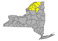
Mohawk River Watershed
The Mohawk River originates in the western Adirondacks and the Tug Hill Plateau and flows 140 miles to the east where it joins the Hudson River. Sections of the Mohawk River also serve as the New York State Barge (Erie) Canal.
Including Schoharie Creek, West Canada Creek, East Canada Creek; Hinkley Reservoir, Delta Reservoir, Peck Lake, and Schoharie Reservoir; joins the Hudson River below Albany.
Flows draining parts of Schenectady, Oneida, Herkimer, Montgomery, and Albany Counties
- Mohawk River drains an area of 3450 sq miles in Oneida, Herkimer, Montgomery, Schenectady, and Albany Counties. The flow
- at Delta Dam near Rome in Oneida County is flowing much below normal 57% above mean at 172 cfs and down over two feet from the high flow two weeks back, currently 2.13 ft deep;
- near Utica in Herkimer County is unrated, 57.1% above mean at 519 cfs and down another foot, a full four feet lower than two weeks ago, 4.87 ft deep;
- at Little Falls is above normal, 116.6% above mean and coming back up from last week, 2390 cfs and up nearly half a foot, 6.48 ft deep;
- at Fonda is unrated, 206.6% above mean at three times the flow volume of last week, 6920 cfs and up close to two feet, 21.49 ft deep, 18.8°C;
- at Amsterdam in Montgomery County unrated, 137.3% above mean and triple the flow of last week, 5150 cfs and up more than three feet, 21.18 ft deep, 4°C ;
- at Lock 8 near Schenectady in Schenectady County is up a few inches this week, 12.16 ft deep and 20°C with a specific conductance of 279 µS/cm;
- at Freeman’s Bridge in Schenectady County is unrated, flowing 64.7% above mean at 2450 cfs and coming back up again, 12.18 ft deep (flood stage 20ft);
- at Rexford in Saratoga County the flow is up just slightly, 12.09 ft, 20.3°C and 318 µS/cm;
- at Vischer Ferry Dam is a bit deeper this week, 12.03 ft deep;
- at Cohoes in Albany County is flowing normal, 52.5% above mean at 1860 cfs and down a bit more this week, 9.01 feet deep above the confluence with the Hudson River (flood stage 20ft). (updated 06-23-22)
Listed 303d for aluminum, copper, low oxygen, fecal coliform, PCBs
- Oriskany Creek drains an area of 144 sq miles in Oneida County into the Mohawk River. The flow at Oriskany is unrated, 59.5% above mean at 95.8 cfs and down more than half a foot, 2.6 ft deep (updated 06-23-22)
- Sauquoit Creek drains an area of 59.8 sq miles of Oneida County into the Mohawk River. The flow at Whitesboro is unrated, 84.25% above mean at 46.7 cfs and down further this week, 1.84 ft deep. (updated 06-23-22)
Sauquoit Creek 303d listed in 2002 for PCBs, proposed for delisting in 2022 for flawed original analysis
- Moyer Creek drains an area of 18.2 sq miles in Herkimer County. The flow at Frankfort is unrated, 59.6% above mean at 8.4 cfs and down again, 2.21 ft deep. (updated 06-23-22)
- West Canada Creek drains an area of 560 sq miles in Herkimer County into the Mohawk River. The flow
- near Wilmurt is unrated, 422% above mean at eight times the volume of last week, 2550 cfs and up almost three feet, 5.96 ft deep;
- at Kast Bridge in Herkimer County is rated above normal, 84.1% above mean at 932 cfs and up slightly, 3.13 ft deep. (updated 06-23-22)
West Canada Creek 303d list: Upper and minor tributaries (1203-008) in Herkimer County, listed in 1998, 2004 for pH
- East Canada Creek drains an area of 289 sq miles of Herkimer County into the Mohawk system. The flow at East Creek in Herkimer is rated much above normal, 330.3% above mean flow at 1330 cfs and back up two feet, 29 ft deep (updated 06-23-22)
- Steele Creek drains an area of 26.4 sq miles in Herkimer County into the Mohawk River. The flow at Ilion is unrated, 88.6% above mean at 25.6 cfs and 2.57 ft deep. (updated 06-23-22)
Steele Creek 303d listed in 2004 for total phosphorous; listed in 2004 for silt/sediment, proposed for delisting in 2022 for flawed original analysis
- Fulmer Creek drains an area of 21.7 sq miles of Herkimer County into the Mohawk system. The flow at Mohawk is unrated, 325.45% above mean at 34.4 cfs and 2.56 ft deep. (updated 06-23-22)
- Otsquago Creek drains an area of 61 sq miles in Montgomery County into the Mohawk system. The flow at Fort Plain is much above normal, 342.8% above mean at ten times last week’s volume, 223 cfs and 3.04 ft deep. (updated 06-23-22)
- Canajoharie Creek drains an area of 59.7 sq miles in Montgomery County. The flow at Canajoharie is unrated, 500.5% above mean at 192 cfs and 3.09 ft deep (updated 06-23-22)
- Schoharie Creek drains an area of 886 sq miles of Schoharie County flowing north to join the Mohawk River;
- near Lexington is unrated, 29.1% above mean at 38.8 cfs and 1.93 ft deep;
- at Prattsville is flowing normal, 32.5% above mean at 93.5 cfs and 3.12 ft deep (flood at 12ft);
- at Gilboa is flowing unrated, ---% above mean at 10.3 cfs and 9.38 ft deep (flood stage 17 ft),
- near North Blenheim is unrated, --% above mean at 106 cfs, and 2.25 ft deep;
- at North Blenheim is flowing much below normal, .99% above mean at 4.94 cfs and .84 ft deep;
- at Breakabeen is normal, 33.3% above mean at 92.9 cfs and 1.19 ft deep (flood stage 11ft);
- at Middleburgh is not rated, 73.9% above mean at 120 cfs and 4.42 ft deep;
- at Schoharie is 4.66 ft deep;
- at Esperance is down again, 1.43 ft deep;
- at Burtonsville in Schoharie County is normal, 20.5% above mean, 135 cfs and .97 ft deep, (flood stage 6ft) (updated 06-23-22)
- Fox Creek drains an area of 99 sq miles in Schoharie County. The flow near Schoharie is unrated, 69.7% above mean at 24.1 cfs and 2.38 ft deep. (updated 06-23-22)
- Little Schoharie Creek drains an area of 18.1 sq miles of Schoharie County. The flow near Middleburgh is unrated, 50.3% above mean at 5.3 cfs and 1.9 ft deep. (updated 06-23-22)
- West Kill drains an area of 27 sq miles in Greene County. The flow
- near Spruceton is unrated, 39.7% above mean, 4.24 cfs and .43 ft deep;
- at West Kill is unrated, 42.9% above mean at 20.3 cfs and 3.17 ft deep. (updated 06-23-22)
- East Kill drains an area of 35.6 sq miles in Greene County. The flow near Jewett Center is unrated, 39.7% above mean at 15.3 cfs and 2.66 ft deep. (updated 06-23-22)
- Manor Kill drains an area of sq miles in Schoharie County. The flow at West Conesville near Gilboa is normal, 49.8% above mean at 14.3 cfs and 1.07 ft deep. (updated 06-23-22)
- Platter Kill drains an area of 10.9 sq miles in Schoharie County. Flow at Gilboa is normal, 116.4% above mean at 9.53 cfs and 1.97 ft deep. (updated 06-23-22)
- Mine Kill drains an area of 16.2 sq miles in Schoharie County. The flow at North Blenheim is above normal, 201.2% above mean at 20.3 cfs and 2.17 ft deep. (updated 06-23-22)
- Batavia Kill drains an area of 68.6 sq miles in Greene County before joining with the Schoharie system. The flow at Red Falls near Prattsville is unrated, 39.5% above mean at 29.5 cfs and 1.96 ft deep. (updated 06-23-22)
- Cobleskill Creek drains an area of sq miles in Schoharie County heads north to join the Mohawk River. The flow at S. Grand Street, Cobleskill is unrated, 188.65% above mean at 55.2 cfs and 3.49 ft deep. (updated 06-23-22)
- 303d listed in 2004 for fecal coliforms.
Impaired Water Bodies (28)
28 sites proposed in 2020-2022 Draft 303d, for details see list on this site.
Schoharie Reservoir receives rainfall and snow melt run-off from an area of 315 sq miles in Schoharie County. Schoharie Reservoir (1202-0012), lake/reservoir in Greene County, listed in 1998 for silt/sediment; recommended for de-listing in 2022 for flawed original analysis
HABs (2)
- Vlaie Pond Large localized bloom confirmed in Schoharie County on June 24.
- North-South Lake Small localized bloom confirmed in Catskills Mountains lake in Greene County on June 24. Reported by the public.
Spills (6)
Fulton County:
-Equipment failure in Fulton County, around 4300 Rt 10, St. Johnsville caused 30 gallons of #2 fuel oil to be spilled. No material was recovered from the environment.
Oneida County:
-Unknown cause in Rome, on South James St, caused unknown amounts of unknown material to be spilled in Oneida County. No material was recovered from the environment.
-Equipment failure in Marcy, on the 6500 block of Factory Rd, caused 10 gallons of antifreeze to be spilled in Oneida County. No material was recovered from the environment.
Schenectady County:
-Equipment failure in Schenectady, on the 600 block of Gordon Dr, caused unknown amounts of hydraulic oil to be spilled in Schenectady County. No material was recovered from the environment.
-Equipment failure in Schenectady, on the 300 block of Seneca St, caused 1 gallon of hydraulic oil to be spilled in Schenectady County. No material was recovered from the environment.
-Deliberate cause in Schenectady, 400 block of Hedgeman St, caused unknown amounts of raw sewage to be spilled. No material was recovered from the environment.
Lower Hudson River Watershed –
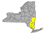
The Lower Hudson Watershed begins where the Mohawk River joins the Hudson system at the Troy Dam and extends down to Manhattan. The lower end of the Hudson system, 153 miles, is technically a tidal estuary, not a river.
Rondout/Wallkill Rivers, Stockport/Kinderhook Creeks, Catskill Creek, Esopus Creek, Croton River; Ashokan Reservoir, Rondout Reservoir, New Croton Reservoir, Alcove Reservoir, Cross River Reservoir, Muscoot/Upper New Croton Reservoir
Flows catching parts of Albany, Rensselaer, Dutchess, Columbia, Ulster Counties
- Lower Hudson River drains the bottom end of a total area more than 12,600 sq miles in New York State.
- At Green Island in Albany County, the Hudson is flowing below normal, 41.2% above mean at 3910 cfs and down slightly, 15.04 ft deep (flood stage 21.5);
- at Albany is -1.02 ft deep (flood stage 11 ft) 20.9°C;
- at Port of Albany, flow is reporting -.88 ft deep, 21.1°C and 264 µS/cm;
- the tidal estuary near Poughkeepsie station in Dutchess County flow is 2.79 ft deep, 273 µS/cm
- at South Dock at West Point in Orange County is 2.03 ft, 20.7°C with specific conductance of 1670 µS/cm;
- at Piermont the flow is not rated, 3.3 ft deep (USGS flood stage 4.3 ft) 2°C and 5330 µS/cm (temp and conductivity readings are the same last 2 months) (updated 06-23-22)
Lower Hudson 303d listed in 2022 for Aluminum, Copper, Iron and Total Phenols. A listing in 1998 for PCBs is suggested for delisting in 2022 due to flaws in original analysis.
- Normans Kill drains 168 sq miles of Albany County. The flow
- at Karlsfield is not rated, 8.25 ft deep;
- the flow at Albany is unrated, 49.1% above mean at 35.1 cfs and 2.91 ft deep. (updated 06-23-22)
- Esopus Creek drains an area of 419 sq miles of Ulster County;
- below Lost Clove Rd at Big Indian in Ulster the flow is unrated, 91% above mean at 31.8 cfs and 2.97 ft deep;
- at Allaben is normal, 31.4% above mean at 35.8 cfs and up slightly, 3.21 ft;
- at Coldbrook is rated normal, 76% above historic mean at 440 cfs and steady depth, 4.52 ft deep (flood 11ft) and 16.5°C;
- near Lomontville is unrated, 92.9% above mean at 30.6 cfs and 2.53 ft deep;
- at Mount Marion is normal, 30.3% above mean at 108 cfs and 12.87 ft deep (flood stage 20 ft). (updated 06-23-22)
Esopus Creek 303d listed in 2012 for turbidity; Esopus Creek, Upper, including minor tributaries (0007) in Ulster County, listed in 1998 for silt/sediment, considered for delisting in 2022 due to flawed original analysis.
- Stony Clove Creek drains an area of 30.9 sq miles in Ulster County before entering the Ashokan Reservoir. The flow below Ox Clove at Chichester is unrated, 39.4% above mean at 23.8 cfs and 2.35 ft deep. (updated 06-23-22)
- Birch Creek drains an area of 12.5 sq miles in Ulster County and enters the Ashokan Reservoir. The flow at Big Indian is unrated, 48.5% above mean at 10.9 cfs and 2.91 ft deep. (updated 06-23-22)
- Beaver Kill drains an area of sq miles in Ulster County before joining Esopus Creek. The flow at Mount Tremper is unrated, 131.5% above mean at 41.4 cfs and 6.08 ft deep. (updated 06-23-22)
- Woodland Creek drains an area of 20.6 sq miles of Ulster County. The flow
- at Wilmot Way near Woodland is unrated, 5.3 ft deep; (same as last week)
- at Phoenicia is unrated, 42.2% above mean at 11.1 cfs and 3.79 ft deep. (updated 06-23-22)
- Valatie Kill drains an area of 9.8 sq miles of Rensselaer County before joining the Hudson; the flow near Nassau is normal, 23.5% above mean at 1.32 cfs and 1.03 feet deep. (updated 06-23-22)
Valatie Kill 303d listed in 2010 for PCBs, considered for delisting in 2022 due to flaws in the original analysis.
- Bush Kill drains an area of 69.3 sq miles of Ulster County before entering the Ashokan Reservoir. The flow below Maltby Hollow Brook at West Shokan is unrated, 52.3% above mean at 19.6 cfs and 2.43 ft deep. (updated 06-23-22)
- Hollow Tree Brook drains an area of 1.95 sq miles in Greene County, joining the Stony Clove Brook and entering Ashokan Reservoir. The flow at Lanesville is unrated, 42.3% above mean at 1.9 cfs and 2.15 ft deep. (updated 06-23-22)
- Myrtle Brook drains an area of 1.81 sq miles in Greene County. Flow at Edgewood is unrated, 58.5% above mean at 1.62 cfs and 3.86 ft deep. (updated 06-23-22)
- Warner Creek drains an area of 8.71 sq miles in Ulster County. Flow at Chichester is unrated, 101% above mean at 13.8 cfs and 1.41 ft deep. (updated 06-23-22)
- Kinderhook Creek drains an area of 329 sq miles in Columbia County before joining the Hudson River. The flow at Rossman is normal, 52.7% above mean at 143 cfs and 2.14 ft deep. (updated 06-23-22)
- Wappinger Creek drains an area of 181 sq miles of Dutchess County; the flow at Wappinger Falls is normal, 43.5% above mean at 76.8 cfs and 3.02 ft deep (flood stage 8ft) (updated 06-23-22)
- Rondout Creek drains an area of 383 sq miles in Ulster County;
- at Lowe’s Corners is normal, 72.2% above mean at 54.8 cfs and 2.89 ft deep;
- at Rosendale is normal, 26.8% above mean at 129 cfs and 9.1 ft deep (flood stage 18 ft)(updated 06-23-22)
- Chestnut Creek drains an area of 20.9 sq miles in Sullivan County. The flow at Grahamsville is normal at 98.75% above mean at 29.2 cfs and .7 ft deep. (updated 06-23-22)
- Croton River drains an area of 378 sq miles of Westchester County into the Croton Reservoir for the New York City water supply. The flow at New Croton Dam near Croton-on-Hudson is rated above normal at 79% above mean at 187 cfs and 2.16 ft deep. (updated 06-23-22)
Croton Reservoir 303d listed in 2018 for low dissolved oxygen and total phosphorous in excess of standard
- West Branch Croton River drains 80.4 sq miles of the Croton River basin in Westchester County. The flow
- at Richardsville is unrated, 44% above historic mean at 5.41 cfs and .96 ft deep;
- below dam near Kent Cliffs is unrated, 31.5% above historic mean at 9.98 cfs and 1.27 ft deep;
- near Carmel flow is 25.85% above historical mean flow at 9.4 cfs and .91 ft deep; (reading same as last week)
- near Croton Falls is unrated, 27.6% above historical mean flow at 31.4 cfs and 3.18 ft deep (updated 06-23-22)
- East Branch Croton River drains an area of 81 sq miles of the Croton River basin in Westchester County. The flow
- near Putnam Lake is unrated, 53.9% above historic mean at 41.3 cfs and 3.09 ft deep;
- at Brewster is unrated, flowing 53.3% above historic mean at 55.8 cfs and 3.14 ft deep;
- at Croton Falls is 59.2% above mean at 50 cfs and 1.65 ft deep (reading same as last week (updated 06-23-22)
- Horse Pound Brook drains an area of 3.94 sq miles in Putnam County, east of the Hudson River, into the New Croton Reservoir. The flow near Lake Carmel is 41.85% above mean at 1.9 cfs and .6 ft deep. (updated 06-23-22)
- Cross River drains an area of 29.9 sq miles of the Croton River basin in Westchester County. The flow
- near Cross River is 37.9% above mean at 7.98 cfs and 1.77 ft deep,
- at Katonah is 27% above historic mean at 9.83 cfs and 1.33 ft deep. (updated 06-23-22)
- Titicus River drains an area of 23.8 sq miles of the Croton River basin in Westchester County. The flow
- at Salem Centre is unrated, 22.5% above mean at 4.99 cfs and 1.76 ft deep;
- at Purdys Station is unrated: 27.2% above mean at half last week’s volume, 8.52 cfs and 1.57 ft deep; (updated 06-23-22)
- Muscoot River drains an area of 19.7 sq miles of the Croton River basin in Westchester County into the Croton River and New Croton Reservoir. The flow
- below dam at Amawalk is unrated, 45.7% above mean at 12.2 cfs and 8.24 ft deep;
- at Baldwin Place is 24.8% above historical mean at 4.45 cfs and 3.97 ft deep. (updated 06-23-22)
Muscoot River 303d listed in 2018 for ammonia and low dissolved oxygen
- Wallkill River drains an area of 695 sq miles in Ulster County. The flow at Gardiner is normal, 30.4% above mean at less than half last week’s flow, 211 cfs and down half a foot, 34 ft deep (flood stage 13 ft) (updated 06-23-22)
Wallkill River 303d listed in 2022 for pH, and 2018 for total phosphorous.
Impaired Water Bodies (80)
80 distinct water bodies appear on the new Draft list in the Lower Hudson River Watershed. Note that each lake/reservoir or section of creek/river may have multiple impairments listed, and each impairment has its own line in the official list, but for our purposes here, we count an impaired water body once. Of the 80 listed, 8 are reservoirs; 14 sites have been put forward for one or more contaminants being delisted. See full listing at wtny.us
- Wiccopee Reservoir (0153) in Putnam County, listed in 2022 for iron in excess of standards
- Melzing Reservoir (0183) in Dutchess County, listed in 2022 for iron
- Vly Creek Reservoir (0234) in Albany County, listed in 2022 for low dissolved oxygen
- Croton Falls Reservoir minor tributaries (0001) in Putnam County
- Browns Pond Reservoir (0013) in Orange County, listed in 2018 for total phosphorous
- Beacon/Cargill Reservoir (0017) in Putnam County, listed in 2022 for dissolved oxygen, iron and pH
- Ashokan Reservoir (0004) in Ulster County, listed in 1998 for silt/sediment is now considered for delisting in 2022 due to flawed original analysis
- Basic Creek Reservoir (0001) in Albany County, listed in 2022 for low dissolved oxygen
- Watervliet Reservoir (0001) in Albany County listed in 2018 for low dissolved oxygen, listed in 2022 for iron and manganese
Hazardous Algae Blooms - HABs (17)
- Nooteeming Lake, small localized bloom confirmed in Dutchess County on June 29. Reported by NYS Department of Health.
- Deer Lake
- Small localized bloom confirmed June 30, by the location tag on the map appears about halfway down the shoreline on the west side of the lake. Reported by NYS DOH in Dutchess County.
- A second small localized bloom is confirmed at what appears to be the same site on Deer Lake as of June 29. Reported by NYS DOH in Dutchess County.
- Putnam Lake
- widespread/lakewide bloom confirmed June 29 in Putnam County. Reported by NYS Dept of Health. The location tag indicates the bloom to be mid-lake in the south end, off Waterford Road.
- Small localized bloom confirmed June 29 in Putnam County, also reported by the NYS Dept. of Health. From the location tag, this bloom appears to be at the south-east shore, closest intersection on land appears to be Jackson Rd and Lakeshore Dr.
- Lake Carmel (has an outlet flowing into the west branch of the Croton River, eventually reaches the Croton Reservoir, City of New York water source.)
- small localized bloom confirmed toward the south end of the lake, off the west shore. This bloom was reported June 26 in Putnam County by NYS DOH.
- A second small localized bloom was confirmed on Lake Carmel on June 26. By the location tag, this bloom appears to be located in the south end of the lake, off the east shore, or possibly on the shore itself. Reported in Putnam County by NYS DOH.
- Lake Casse
- Small localized bloom confirmed on June 23, appearing at the shoreline of the point beach at the north end of the lake. Reported in Putnam County by NYS DOH. Another 2022 bloom record was posted for this lake on June 13 has been archived.
- Roaring Brook Lake
- Small localized bloom confirmed on June 26 on the west side of the lake.
- Reported in Putnam County by CSLAP.
Note: A small localized bloom on this same lake reported May 21 has been archived.
- Lake Peekskill
- a small localized bloom has been confirmed on June 29. The bloom appears to be located the southwest corner beach. Reported by NYS DOH in Putnam County.
- A second small localized bloom confirmed June 26 appears to be north of the point, along the east shore, closest landmark is Point Dr. N. Reported by NYS DOH in Putnam County.
- A third small localized bloom confirmed June 26 appears from the map tag right on shore in the north end of the lake off Northway Rd. Reported by NYS DOH in Putnam County.
- Lake Lincolndale, a large localized bloom confirmed June 19 appears to be situated in the centre of the water body. Reported in Westchester County by CSLAP. A previous bloom on this lake reported June 5 has been archived.
- Mohegan Lake
- a widespread/lakewide bloom confirmed June 19 appears by the location tag to be in the middle of the lake. Reported in Westchester County by the public.
- A second report for Mohegan Lake has been confirmed June 28, a small localized bloom appearing along the Mohegan Colony Beach. This is reported by NYS DOH in Westchester County.
- Lake Tiorati, large localized bloom confirmed June 24. Reported by NYS Parks in Orange County.
Spills (23)
Westchester County:
-equipment failure in Yorktown, on Overhill Rd, caused unknown amounts #2 fuel oil to be spilled. No material was recovered from the environment.
-Equipment failure in Armonk, on the 0-100 block of Limestone Rd, caused unknown amounts of #2 fuel oil to be spilled. No material was recovered from the environment.
-Human error in Armonk, on the 0-100 block of Brundage St, caused 1 gallon of #2 fuel oil to be spilled. No material was recovered from the environment.
-Equipment failure in Tarrytown, on the 100 block of Old White Plains, caused unknown amounts of gasoline to be spilled. No material was recovered from the environment.
-Equipment failure in Mt Vernon, on the 0-100 block of Lyons Place, caused 1000 gallons of dielectric fluid to be spilled. No material was recovered from the environment.
-Equipment failure in Mt Kisco, on the 0-100 block of Highland Ave, caused unknown amounts of #2 fuel oil to be spilled. No material was recovered from the environment.
-Equipment failure in Mount Vernon, on the 0-100 block of Lyon St, caused 850 gallons of transformer oil to be spilled. No material was recovered from the environment.
-Equipment failure in Armonk, on the 0-100 block of Green Valley rd, caused unknown amounts of #2 fuel oil to be spilled. No material was recovered from the environment.
Putnam County:
-Equipment failure in Putnam, on the 0-100 block of Cindy Lane, caused unknown amounts of #2 fuel oil to be spilled. No material was recovered from the environment.
Columbia County:
-Traffic accident in Hudson, on the 144 Rt 27B, caused 30 gallons of transformer oil to be spilled. No material was recovered from the environment.
Albany:
-Equipment failure in Albany, on the 300 block of 1st street caused unknown amounts of unknown petroleum to be spilled. No material was recovered from the environment.
-Equipment failure in Watervliet, on the 200 block of 7th Ave, caused 2 units of transformer oil to be spilled. No material was recovered from the environment.
-Equipment failure in Latham, on the 0-100 block of Laura Drive, caused 5 gallons of non-PCB oil to be spilled. No material was recovered from the environment.
-Equipment failure in Glenmont, on the 500 block of River Road, caused 15 gallons of gasoline to be spilled. No material was recovered from the environment.
-Equipment failure in Albany, on the 700 block of Albany Shaker Road, caused 40 gallons of jet fuel to be spilled. No material was recovered from the environment.
Orange County:
-Traffic accident in Cornwall, on the 0-100 block of Ridge Rd, caused 20 gallons of motor oil and hydraulic oil to be spilled. No material was recovered from the environment.
-Equipment failure in Warwick, on the 0-100 block of Belcher Rd, caused unknown amounts of #2 fuel oil to be spilled. No material was recovered from the environment.
-Equipment failure in Highland Hills, on the 700 block of Route 32, caused unknown amounts of #2 fuel oil to be spilled. No material was recovered from the environment.
-Equipment failure in Highland Hills, on the 0-100 block of Stanford Dr, caused unknown amounts of transformer oil to be spilled. No material was recovered from the environment.
-Unknown cause in Goshen, on the 0-100 block of Gibson Rd, caused unknown amounts of unknown petroleum to be spilled. No material was recovered from the environment.
Rensselaer County:
-Equipment failure in Troy, on the 200 block of Hoosick St, caused 1 gallon of transformer oil to be spilled. No material was recovered from the environment.
- Equipment failure in Castle on Hudson, on the 1835 RT 9, caused 50 gallons of wastewater to be spilled. No material was recovered from the environment.
-Equipment failure in Troy, on the 500 block of Hoosick St, caused 1 gallon of transformer oil to be spilled. No material was recovered from the environment.
Delaware River Watershed
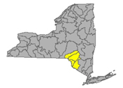
Delaware River headwaters flow down from the Catskill Mountains into Delaware Bay/Atlantic Ocean. The watershed area includes East Branch Delaware River, West Branch Delaware River, Neversink River, Mongaup River, Pepacton Reservoir, Cannonsville Reservoir and Neversink Reservoir.
Flows streaming over parts of Delaware, Ulster, Sullivan Counties
- East Branch Delaware River drains an area of 458 sq miles in Delaware County. The flow
- at Roxbury is unrated
- at Margaretville is normal, 80.4% above mean at 158 cfs and 2.85 ft deep (flood stage 11ft) 15.5°C and 105 µS/cm;
- at Downsville in Delaware County reporting normal, 54.8% above mean, 135 cfs and 3.12 ft deep (flood stage 9ft) 5.9°C;
- at Harvard, flow is above normal, 184.5% above mean at 648 cfs and 3.85 ft deep, (flood stage 10 ft) 12.3°C;
- at Fishs Eddy is above normal, 203.4% above mean at 1840 cfs and up half a foot, 6.07 ft deep, (flood stage 13 ft) 13.8°C; (updated 06-23-22)
- West Branch Delaware River drains an area of 595 sq miles of Delaware County. The flow
- at Hobart is unrated, 44.2% above mean at 8.03 cfs and .97 ft deep;
- upstream from Delhi is normal, 106.7% above mean at 151 cfs and 2.7 ft deep (flood stage 8ft);
- at Walton in Delaware County is above normal, 187.9% above mean at 639 cfs and up more than a foot, 4.75 ft deep, (flood stage 9.5) 16.6°C and 121 µS/cm;
- at Stilesville in Delaware County is normal, 86.75% above mean at 496 cfs and 8.03 ft deep, 8°C;
- at Hale Eddy in Delaware County is normal, 108.9% above mean flow at 797 cfs and down half a foot, 3.39 ft deep, (flood stage 11 ft) 11.8°C; (updated 06-23-22)
- West Brook drains an area of sq miles in Delaware County. The flow at Austin Lincoln Park at Walton is unrated, 395% above mean at 84.9 cfs and 4.2 ft deep. (updated 06-23-22)
- Town Brook drains 14.3 sq miles in Delaware County. The flow southeast of Hobart is unrated, 62.2% above historic mean, 9.79 cfs and 1.29 ft (flood stage 7 ft) (updated 06-23-22)
- Dry Brook drains an area of 82.2 sq miles in Delaware County. The flow at Arkville is unrated, 59.3% above mean at 81.2 cfs and 1.79 ft deep. (flood stage 10.5 ft) (updated 06-23-22)
- Trout Creek drains an area of 20.2 sq miles in Delaware County direct to the Delaware River. The flow at Trout Creek is above normal, 201.2% above mean, 37 cfs and 3.69 ft deep (flood stage 6.3 ft). (updated 06-23-22)
- Little Delaware River drains an area of 49.8 sq miles in Delaware County into the Delaware River. The flow near Delhi is above normal, 131.2% above mean at 64.5 cfs and 2.56 ft deep. (updated 06-23-22)
- Platte Kill drains an area of 34.9 sq miles in Delaware County. The flow at Dunraven is above normal, 105.95% above mean at 39.9 cfs and 3.18 ft deep (flood stage 7ft) (updated 06-23-22)
- Beaver Kill drains an area of 241 sq miles in Delaware County. The flow at Cooks Falls is above normal, 164.25% above mean at 625 cfs and up half a foot, 3.02 ft deep, (flood stage 10 ft) 14.4°C. (updated 06-23-22)
- Tremper Kill drains an area of 33 sq miles of Delaware County; the flow near Andes is above normal, 153.3% above mean at 34.7 cfs and 2.85 ft deep, (flood stage 6.8 ft) 14.7°C and 92 µS/cm (updated 06-23-22)
- Mill Brook drains an area of 25.2 sq miles in Delaware County. The flow at Dunraven is normal, 81.7% above mean at 30.3 cfs and 3.07 ft deep, 13.7°and 43 µS/cm (updated 06-23-22)
- Neversink River drains an area of 93 sq miles in Ulster, Orange, and Sullivan Counties. Neversink River
- near Claryville in Sullivan County is above normal, 102.7% above mean at 151 cfs and 6.55 ft deep, (reading the same as last week) 13.1°C and 28 µS/cm;
- at Neversink is flowing above normal, 94.5% above mean at 131 cfs and 3.53 ft deep, (reading same as last two weeks) 7.7°C and 28 µS/cm;
- at Bridgeville is not rated, 145.35% above mean at 370 cfs and 5.48 ft deep (flood stage 13 ft), 13.7°C and 85 µS/cm;
- at Godeffroy in Orange County is above normal, 103.9% above mean at 482 cfs and 4.05 ft deep (flood stage 10ft), 15.8°C and 98 µS/cm. (updated 06-23-22)
- West Branch Neversink River drains an area of 33.8 sq miles in Sullivan County.
- At Winnisook Lake near Frost Valley headwaters, the flow is unrated, 59% above mean at .72 cfs and 1.26 ft deep, 10ºC and 13 µS/cm;
- at Claryville the flow is unrated, 94.6% above mean at 68.3 cfs and 6.16 ft deep, 13°C and 29 µS/cm (updated 06-23-22)
- East Branch Neversink River drains an area of 22.9 sq miles in Ulster County. The flow
- northeast of Denning flow is not rated, 69.1% above mean at 14.3 cfs and 1.16 ft deep, 11.1°C and 12 µS/cm;
- near Claryville is not rated, 96.3% above mean at 50.1 cfs and 4.96 ft deep, 12.5°C and 20 µS/cm; (updated 06-23-22)
- Delaware River drains an area of 1820 sq miles of Delaware County and across the state line to empty into. The flow
- at Lordville is unrated, 221.7% above mean at 5480 cfs and up half a foot, 8.98 ft deep, (flood stage 20 ft) 15°and 58 µS/cm;
- at Callicoon is much above normal, 411.4% above mean at 8340 cfs and up half a foot, 5.41 ft deep, (flood stage 12 ft) 15ºC and 51 µS/cm;
- near Barryville is much above normal, 416.7% above mean at 10400 cfs and up over a foot, 6.99 ft deep (flood stage 17ft) 16.2°C;
- at Port Jervis the flow is above normal, 186% above mean at 7690 cfs and 4.67 ft deep; (flood stage 18 ft) 17.8°C and 87 µS/cm. (updated 06-23-2022)
- Callicoon Creek drains an area of 110 sq miles in Sullivan County. The flow at Callicoon is much above normal, 201.9% above mean at 268 cfs and 1.93 ft deep (flood stage 7ft) 16.1°C, (updated 06-23-2022)
- Mongaup River drains an area of 200 sq miles in Sullivan County. The flow
- near Mongaup Valley is unrated, 135.15% above mean at 200 cfs and 3.65 ft deep (flood stage 14ft),
- near Mongaup flow is normal, 62.2% above mean at 155 cfs and down to half last week’s depth, 1.64 ft deep, 16.9°C and 120 µS/cm (updated 06-23-2022)
Impaired Water Bodies (25)
25 Water bodies appear on the latest Draft 303(d) list for the Delaware River watershed in 2022, with 2 suggestions for delisting, in whole or in part.
For more details, check out the posted list under the Delaware tab.
Hazardous Algae Blooms HABs (1)
- Silver Lake, widespread/lakewide bloom confirmed in Sullivan County on June 30. Reported by DEC staff.
Spills (9)
Sullivan County:
-Traffic accident in Thompson Ridge, on 632 Route 48, caused unknown amounts of motor oil to be spilled. No material was recovered from the environment.
-Human error in Hortonville, on the 4288 State Rt 17B, caused 15 gallons of diesel to be spilled. No material was recovered from the environment.
-Equipment failure in Eldred, on 435 Route 55, caused unknown amounts of #2 fuel oil to be spilled. No material was recovered from the environment.
-Housekeeping in Callicoon, on the 4288 NY-17B, caused 10 gallons of diesel to be spilled. No material was recovered from the environment.
-Unknown cause in Neversink, on NY-55, caused unknown amounts of unknown petroleum to be spilled. No material was recovered from the environment.
Ulster County:
-Unknown cause in Gardiner, on the 1000th block of Albany Post Rd, caused unknown amounts of #2 fuel oil to be spilled. No material was recovered from the environment.
-Equipment failure in New Paltz, on the 500 block of Swartekill Rd, caused unknown amounts of #2 fuel oil to be spilled. No material was recovered from the environment.
-Equipment failure in Kingston, on the 200 block of Washington Ave, caused unknown amounts of #2 fuel oil to be spilled. No material was recovered from the environment.
-Equipment failure in Lake Katrine, on the 0-100 block of Jeanette Lane, caused 5 gallons of transformer oil to be spilled. No material was recovered from the environment.
Housatonic River Watershed
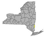
A small portion of the headwaters of the Housatonic lie in eastern New York State. These waters drain the Taconic and Berkshire Mountains before joining the Housatonic and eventually emptying into Long Island Sound. Includes Tenmile River, Green River, Indian Lake, Swift/Crane Ponds
Flows: parts of Dutchess County
- Housatonic River drains an area of 282 sq miles in Dutchess County. The river itself is not located in New York state, but it does receive run-off from Dutchess County; near Great Barrington, MA is flowing normal, 51.5% above mean at 193 cfs and 2.1 ft deep; (06-23-22)
- Green River drains an area of 51 sq miles of Dutchess County. The flow
- near Williamstown, MA is normal, 65.8% above mean at 34.4 cfs and 1.77 ft deep;
- at Great Barrington is normal, 34.8% above historic mean at 20.5 cfs and .69 ft deep. (updated 06-23-22)
Impaired Water Bodies (0)
Hazardous Algae Blooms – HABs (1)
- Unnamed Water Body (Pawling) widespread or lakewide bloom confirmed in Dutchess County on June 21. Reported by the Public.
Spills (2)
Dutchess County:
-Storm in Hopewell Junction, on the 0-100 block of Shadow Wood Dr, caused unknown amounts of transformer oil to be spilled. No material was recovered from the environment.
Orange County:
-Equipment failure in Cuddybackville, on the 0-100 block of Galley Hill Rd, caused 5 gallons of transformer oil to be spilled. No material was recovered from the environment.
Atlantic Ocean/Long Island Sound Watershed
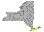
The Atlantic Ocean/Long Island Sound Watershed drains most of the New York City Metropolitan Area and all of Long Island. The drainage area includes all marine waters in New York Harbor, Long Island Sound, Block Island Sound, and along the South Shore of Long Island, and the fresh waters that drain into them.
Includes 1415 square miles of marine estuary waters, the Bronx River, Mamaroneck River, Mianus River, Peconic River, Kensico Reservoir, Lake Ronkonkoma.
Flows taking in run-off from parts of Bronx, Queens, Kings, Suffolk, Nassau and New York Counties
- Bronx River drains an area of 38.4 sq miles of Bronx County. The flow at NY Botanical Garden is unrated, 50.8% above mean at 36.4 cfs and .7 ft deep (flood stage 3ft) 18°C and 930µS/cm (updated 06-24-22)
- Valley Stream drains 3.77 sq miles in Nassau County. The flow at Valley Stream has been monitored for 65 years. This week flow is normal, 77.15% above mean at 2.33 cfs and 1.04 ft deep. (updated 06-24-22)
- East Meadow Brook drains an area of 28.7 sq miles of Nassau County. The flow at Freeport is below normal, 15.6% above mean at 1.81 cfs and .27 ft deep (updated 06-24-22)
- Massapequa Creek drains an area of 38.6 sq miles in Nassau County. The flow at Massapequa is below normal, 42.2% below mean at 3.66 cfs and .68 ft deep. (updated 06-24-22)
- Carlls River drains an area of 35.4 sq miles in Suffolk County. The flow at Babylon is normal, ---% above mean, 18.8 cfs and down three quarters of a foot, .68 ft deep. (updated 06-24-22)
- Sampawams Creek drains an area of 22.7 sq miles in Suffolk County. The flow at New Babylon is below normal, 63.7% above mean at 6.1 cfs and .58 ft deep (updated 06-24-22)
- Bellmore Creek tributary drains less than 1 sq mile in Suffolk County. The flow near Bellmore is normal, 8.7 % above mean at .21 cfs and 2.06 ft deep. (06-24-22)
- Connetquot Brook drains an area of 21.9 sq miles in Suffolk County. The flow at Central Islip is normal: 103.5% above mean at 28.2 cfs and 2.88 ft deep. (updated 06-24-22)
- Swan River drains an area of 8 sq miles in Suffolk County. The flow at East Patchogue is below normal, 79.5% above at 10.3 cfs and .54 ft deep. (readings same as last week) (updated 06-24-22)
- Carmans River drains an area of 73 sq miles in Suffolk County. The flow at Yaphank is normal, 102.5% above mean at 25.8 cfs and 1.22 ft deep (reading same as last week) (06-24-22)
- Peconic River drains an area of 74.7 sq miles of Suffolk and Nassau Counties. The flow
- at Riverhead is normal: 67.7% above mean at 25.7 cfs and .45 ft deep;
- at County Hwy 105 is not rated, tidal flow depth 2.12 ft deep (flood stage 4.44 ft) 22.9°C and 40600µS/cm (updated 06-24-22)
- Mill Neck Creek drains an area of 8.58 sq miles of Nassau County. The flow at Mill Neck is normal, 107.8% above mean at 9.29 cfs and .23 feet deep. (updated 06-24-22)
- Cold Spring Brook drains an area of 7.83 sq miles in Nassau County. The flow at Cold Spring Harbour is normal, 104.1% above mean at 2.78 cfs and .26 ft deep (updated 06-24-22)
- Nissequogue River drains an area of 27 sq miles in Nassau County. The flow at Smithtown is normal, 88.55% above mean at 38.5 cfs and .7 ft deep, (reading same as last week) 17.9ºC and 250µS/cm (updated 06-24-22)
Impaired Water Bodies (200)
200 water bodies appear on the Draft 303(d) list for Atlantic Ocean/Long Island Sound watershed in 2020-2022, up from 49 sites on the 2018 list. Of the 200, 49 are proposed for delisting, in whole or in part.
For more details, check out the posted list under the Atlantic/LIS tab.
Hazardous Algae Blooms - HABs (20)
- Lake Waccabuc, widespread/lakewide bloom confirmed June 26, appears from the NYHABs map location to be in a cove on the east side, closest intersection Cove Rd at Lake View Rd. Reported by CSLAP in Westchester County.
- Sheldrake Lake, large localized bloom confirmed June 22. The map location tag puts this bloom on the east shore of the main lake about half way down. Reported by the public in Westchester County.
- Sheldrake Lake, photo supplied by public, posted on NYHABs site
- Glenwood Lake, a widespread/lakewide bloom confirmed on June 21. The location tag puts this bloom right in the centre of the water body. Reported by the public
- Harlem Meer, small localized bloom confirmed on the north end of Central Park June 30. Report to NYHABs by the NYC Parks Dept in New York County.
- Turtle Pond, large localized bloom confirmed in Central Park June 30. Reported by NYC Parks in New York County.
- The Lake in Central Park, widespread/lakewide bloom confirmed June 30. Reported by NYC Parks in New York County.
The Lake in Central Park, June 30, 2022, credit NYC Parks
- Prospect Park Lake
- Widespread/lakewide bloom confirmed June 24 at the narrow north tip of the water body. Reported by NYC Parks in Kings County (Brooklyn)
- Another widespread bloom has been confirmed as of July 1; reported by NYC Parks.
- Two previous blooms this season have been archived.
- Goose Pond in Captain Tilly Park, widespread/lakewide bloom confirmed June 21. Reported by NYC Parks in Queens County. A bloom confirmed earlier this season has been archived.
- Roth Pond, on campus of Stony Brook University, widespread/lakewide bloom confirmed June 22. Reported by Stony Brook University in Suffolk County. Seven previous confirmed algae blooms have been archived, dating back to April 21 of this season.
- Maratooka Lake in Mattituck, a bloom of unreported extent has been confirmed as of June 27. Reported by Stony Brook U in Suffolk County.
- Wainscott Pond of the Hamptons, shows two active widespread/lakewide blooms, the first confirmed June 21, the second June 29. Reported by Stony Brook in Suffolk County. Four previous blooms recorded this season have been archived.
- Agawam Lake near the Hampton Bays has two confirmed – two widespread/lakewide blooms, the first reported June 21 and the second reported June 29 by Stony Brook U in Suffolk County. Five blooms have been recorded previously this season and archived.
- Beaver Dam Lake
- A widespread bloom was confirmed as of June 26. Reported by the public in Orange County.
- Large, localized bloom confirmed June 29. Reported by the public in Orange County.
- A second large localized bloom has been confirmed June 30, also reported by the public in Orange County.
- Eight prior confirmed blooms have been archived this season.
- Example of a localized bloom on Beaver Dam Lake, June 30. Credit NYHABs, submitted by the public.
- Mill Pond (Watermill) , a bloom of unreported extent confirmed June 29. This bloom does not show up on the NYHABs map, it was reported by Stony Brook University in Suffolk County.
- Lake Welch, widespread/lakewide bloom confirmed June 26. Not yet appearing on the NYHABs interactive map, this bloom was reported by NYS Parks in Rockland County.
Spills (35)
Westchester County:
-Equipment failure in Tuckahoe, on the 0-100 block of Fulling Ave, caused unknown amounts of #2 fuel oil to be spilled. No material was recovered from the environment.
-Equipment failure in White Plains, on the 0-100 block of Florence Ave, caused unknown amounts of #2 fuel oil to be spilled. No material was recovered from the environment.
-Equipment failure in Harrison, on the 1400 block of Old Orchard St, caused unknown amounts of #2 fuel oil to be spilled. No material was recovered from the environment.
-Unknown cause in Mount Vernon, on the 600 block of E Sandford Blvd, caused unknown amounts of unknown material to be spilled. No material was recovered from the environment.
-Human error in Mount Vernon, on the 0-100 block of Bayview Rd, caused 100 gallons of #2 fuel oil to be spilled. No material was recovered from the environment.
-Equipment failure in Harrison, on the 0-100 block of Huston Ave, caused unknown amounts of dielectric fluid to be spilled. No material was recovered from the environment.
New York County (Manhattan):
-Equipment failure in Manhattan, on West 72nd St, caused 0.13 gallons of hydraulic oil to be spilled. No material was recovered from the environment.
Kings County (Brooklyn):
-Unknown cause in Brooklyn, on the 500 block of Herkimer St, caused unknown amounts of raw sewage to be spilled. No material was recovered from the environment.
-Equipment failure in Brooklyn, on Ave S/33/34 St, caused 0.5 gallons of dielectric fluid to be spilled. No material was recovered from the environment.
Unknown cause in Brooklyn, East 8th and Ave H, caused 8 gallons of motor oil to be spilled. No material was recovered from the environment.
Queens County:
-Traffic accident in Queens, on 134th St, caused 100 gallons of diesel to be spilled. No material was recovered from the environment.
-Other cause in Queens, on the 100 block of 31st Ave, caused 1 gallon of gasoline to be spilled. No material was recovered from the environment,
-Equipment failure in Queens, on the 10000 block of Beach Channel Dr, caused 1 gallon of transformer oil to be spilled. No material was recovered from the environment.
-Unknown cause in Queens, at the JFK international, caused 33 gallons of jet fuel to be spilled. 30 gallons of material was recovered from the environment.
-Equipment failure in Corona, on the 1600 block of 109th Ave, caused unknown amounts of transformer oil to be spilled. No material was recovered from the environment.
-Equipment failure in Queens, on 35-58 Vernon Blvd, caused 5 gallons of dielectric fluid to be spilled. No material was recovered from the environment.
-Unknown cause in Queens, on 209-10 93r Ave, caused unknown amounts of motor oil to be spilled. No material was recovered from the environment.
-Equipment failure in Queens, at the JFK Airport, caused 33 gallons of jet fuel to be spilled. No material was recovered from the environment.
-Equipment failure in Queens, at Terminal Gate 30 at JFK, caused unknown amounts of jet fuel to be spilled. No material was recovered from the environment.
-Equipment failure in Queens, on Lakeview Lane and Baisley Blvd, caused 10 gallons of hydraulic oil to be spilled. No material was recovered from the environment.
-Human error in Bayside, on the 200-05 Horace Harding Expressway, caused 100 gallons of gasoline to be spilled. No material was recovered from the environment.
-Equipment failure in Queens, on the 3500 block of 28th St, caused unknown amounts of #2 fuel oil to be spilled. No material was recovered from the environment.
Nassau County:
-Equipment failure in Island Park, on Austin Blvd and Texas Blvd, caused 2 gallons of hydraulic oil to be spilled. No material was recovered from the environment.
-Equipment failure in Hicksville, on the 0-100 block of Hilton Ct, caused 1 gallon of #2 fuel oil to be spilled. No material was recovered from the environment.
Suffolk County:
-Equipment failure in Huntington Station, on the 0-100 block of Oakcrest Dr, caused unknown amounts of #2 fuel oil to be spilled. No material was recovered from the environment.
-Other cause in Deer Park, on the 1900 block of Deer Park Ave, caused unknown amounts of gasoline to be spilled. No material was recovered from the environment.
-Equipment failure in Lindenhurst, on the 700 block of North Monroe Ave, caused 1 gallon of transformer oil to be spilled. No material was recovered from the environment.
-Traffic accident in Montauk, on the 0-100 block of Emery St, caused 20 gallons of transformer oil to be spilled. No material was recovered from the environment.
-Equipment failure in St James, on the 300 block of Old Mill Rd, caused 5 gallons of transformer oil to be spilled. No material was recovered from the environment.
-Other cause in Islip, on the 0-100 block of Skipper Dr, caused unknown amounts of gasoline to be spilled. No material was recovered from the environment.
-Equipment failure in East Setauket, on the 0-100 block of Club House Ct, caused 1 gallon of #2 fuel oil to be spilled. No material was recovered from the environment.
-Equipment failure in Selden on the 0-100 block of majestic Rd, caused unknown amounts of #2 fuel oil to be spilled. No material was recovered from the environment.
-Traffic accident in Islandia, on Lie Eastbound, caused unknown amounts of diesel to be spilled. No material was recovered from the environment.
-Equipment failure in Southam, on the 1600 block of meadow lane, caused 30 gallons of transformer oil to be spilled. No material was recovered from the environment.
Richmond County:
-Equipment failure in Troy, on Amboy Rd, caused unknown amounts of transformer oil to be spilled. No material was recovered from the environment.
Bronx County:
-Equipment failure in the Bronx, on the 400 block of Bruckner Blvd, caused unknown amounts of dielectric fluid to be spilled. No material was recovered from the environment.
Northeast Watersheds
emptying into Atlantic Ocean via St. Lawrence River
Lake Champlain Watershed
The Lake Champlain Watershed drains the area between the Adirondack Mountains in northeastern New York State and the Green Mountains in northwestern Vermont.
Includes the Ausable River, Saranac River, Great Chazy River, Boquet River, Mettawee River, Ticonderoga Creek/Lake George, Lake George,
Upper Saranac Lake, Lower Saranac Lake, Lake Placid, Lake Champlain
Flows concerning parts of Washington, Essex, and Clinton Counties
- Mettawee River drains an area of 167 sq miles of Washington County into Lake Champlain. The flow near Middle Granville is below normal, 31.4% above mean at 47 cfs and 3.26 feet deep (flood stage 7 ft) (updated 06-24-22)
- Boquet River drains an area of 207 sq miles of Essex County. The flow at Willsboro is normal, 103.8% above mean, 279 cfs and 2.98 ft deep. (updated 06-24-22)
- Ausable River drains an area of 198 sq miles of Clinton County. The flow near Au Sable Forks is above normal, 149.2% above mean at 958 cfs and up a foot, 2.59 ft deep (updated 06-24-22)
- East Branch Ausable River drains an area of 198 sq miles in Essex County. The flow at Au Sable Forks is above normal, 98.7% above mean at 288 cfs and up half a foot, 2.02 ft deep; (updated 06-24-22)
- Little Ausable River near Valcour is unrated, 168.1% above mean at 88 cfs and up half a foot, 1.76 ft deep. (updated 06-24-22)
- Salmon River drains an area of 63 sq miles in Clinton County. The flow at South Plattsburgh is much above normal, 282.4% above mean at 154 cfs and 2.03 ft deep (updated 06-24-22)
- Saranac River drains an area of 608 sq miles. The flow at Plattsburgh is above normal, 176.3% above mean at 1300 cfs and up over half a foot, 4.39 ft deep (flood stage 9ft) (updated 06-24-22)
- Great Chazy River drains an area of 243 sq miles in Clinton County. The flow at Perry Mills is flowing high, 1112% above mean at more than quadruple the flow volume, 1880 cfs and up more than a foot and a half, 5.28 ft deep, (flood stage 9ft) (updated 06-24-22)
- Little Chazy River drains an area of 50 sq miles in Clinton County. The flow near Chazy is much above normal, 481% above mean at 212 cfs and up more than a foot, 3.39 feet deep. (updated 06-24-22)
Impaired Water Bodies (29)
29 water bodies appear on the 2022 Draft 303(d) list for Lake Champlain Watershed up from 6 in the last list. Of the 29 total, 12 water bodies are proposed for delisting, in whole or in part.
For more details, check out the posted list under the NE tab.
HABs (0)
As of the date of this report, no HABs have been listed on the NYS DEC.
Spills (2)
Clinton County:
-Equipment failure in Saranac, on 3439 RT 3, caused unknown amounts of gasoline to be spilled. No material was recovered from the environment.
Essex County:
-Unknown cause in Lake Placid on the 2400 block of Main St, caused unknown amounts of unknown petroleum to be spilled. No material was recovered from the environment.
St. Lawrence River Watershed
185 km of the St. Lawrence River catches the runoff from the northern and western Adirondack Mountains, drawing from portions of eight states, a combined area of 5600 square miles.
St. Lawrence Watershed collects the flow from eleven thousand miles of freshwater rivers and streams, including the Oswegatchie River, Raquette River, Saint Regis River, Grass River and Indian River; including Black Lake, Cranberry Lake, Raquette Lake, Tupper Lake and Long Lake. Densely forested woodlands, peatlands and areas of flat agricultural plains make up the natural surface water filtration system of this watershed area.
Flows: parts of St. Lawrence and Franklin Counties
- Raquette River drains 1125 sq miles of St. Lawrence County. The flow
- at Piercefield is normal, 110.5% above mean at 1210 cfs and up almost a foot, 5.67 ft deep (flood stage 12.5 ft);
- at South Colton is much below normal, 4.3% above mean at 63.7 cfs and down almost three feet, 1.97 feet deep (flood stage is 10ft);
- at Raymondville is below normal, 60.5% above mean at half last week’s volume 1020 cfs and down more than half a foot, 2.43 ft deep (updated 06-24-22)
- Regis River drains an area of 612 sq miles in St. Lawrence County. The flow at Brasher Centre is much above normal, 504% above mean at 3860 cfs and up two feet, 8.38 ft deep (floods at 11ft). (updated 06-24-22)
- West Branch St. Regis River drains an area of 171 sq miles in St. Lawrence County. The flow near Parishville is high, 623.55% above mean at 1750 cfs and up two feet, 3.76 ft deep. (updated 06-24-22)
- Little Salmon River drains an area of 92 sq miles of Franklin County. The flow at Bombay is much above normal, 384% above mean at 344 cfs and up two feet, 4.32 ft deep. (updated 06-24-22)
- Grass River drains an area of 598 sq miles in Franklin County. The flow at Chase Mills is unrated, 194.2% at 1300 cfs and up three quarters of a foot, 5.22 ft deep. (updated 06-24-22)
- Oswegatchie River drains an area of 986 sq miles in St. Lawrence County. The flow
- at Oswegatchie is much above normal, 204.9% above mean at 865 cfs and up half a foot, 3.73 ft deep;
- at Heuvelton is above normal, 178.6% above mean at 1810 cfs and 2.74 ft deep. (updated 06-24-22)
- West Branch Oswegatchie River drains an area of 258 sq miles in St. Lawrence County. The flow near Harrisville is above normal, 160.3% above mean at 583 cfs and up more than half a foot, 3.28 ft deep. (updated 06-24-22)
Impaired Water Bodies (41)
41 water bodies appear on the 2022 Draft 303(d) list for St. Lawrence Watershed, up from 4 in the last list. Of the 41 total, 5 are proposed for delisting, in whole or in part.
For more details, check out the posted list under the NE tab.
Spills (1)
St. Lawrence County:
-Equipment failure in Potsdam, on 5984 Route 56, caused unknown amounts of #2 fuel oil to be spilled. No material was recovered from the environment.
Black River Watershed
The Black River headwaters begin in the Adirondack mountains, scoop southwest and then curve northwest, the flow proceeds north-northwest, hooks west and empties into Lake Ontario. Major tributaries in the system include Moose River, Beaver River, Independence River and Deer River, Stillwater Reservoir, Fulton Chain of Lakes, Lake Lila and Big Moose Lake.
Flows: Filters and drains most of Jefferson and Lewis Counties along with parts of Herkimer, Hamilton, and Oneida Counties.
- Black River drains an area of 1864 sq miles of Jefferson County. The flow
- near Boonville is below normal, 42.25% above mean at 220 cfs and down a foot, 4.04 ft deep (flood stage 10ft);
- at Watertown flow is normal, 63.45% above mean, 1740 cfs and down half a foot, 3.21 feet deep (flood at 10ft). (updated 06-24-22)
- Beaver River drains 291 sq miles in Lewis County. The flow at Croghan is normal: 80.5% above mean at 430 cfs and up inches, 2.63 ft deep. (updated 06-24-22)
- Independence River drains an area of 88.7 sq miles in Lewis County. The flow at Donnatsburgh is normal, 77.2% above mean at 121 cfs and 3.77 feet deep, 16.5°C (updated 06-24-22)
Impaired Water Bodies (34)
34 water bodies appear on the 2022 Draft 303(d) list for Black River Watershed, up from one in the last list. Of the 34 total, 2 are proposed for delisting in 2022, in whole or in part.
For more details, check out the posted list under the NE tab.
Spills (1)
Jefferson County:
-Equipment failure in Watertown, on the 22000 block of Fisher Rd, caused unknown amounts of biohazardous waste to be spilled. No material was recovered from the environment.
Northwest Watersheds
emptying into Atlantic Ocean via Great Lakes and St. Lawrence River
Lake Ontario and Minor Tributaries
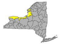
This watershed drains 2460 square miles of northwest New York State, including three areas between the Niagara, Genesee, Oswego and Black Rivers) . It is divided into western, central and eastern sections that stretch all along the Lake Ontario Shoreline.
*Includes Salmon River Reservoir, Sodus Bay, North Pond, Irondequoit Bay and Perch Lake, Salmon River, Oak Orchard Creek, Irondequoit Creek, Sandy Creek
Flows considering most of Jefferson and Orleans Counties, parts of Monroe, Oswego, Wayne and Niagara Counties
- Northrup Creek drains an area of 10.1 sq miles in Monroe County. The flow at North Greece in Monroe County is below normal, 26.9% above mean, less than half the volume of two weeks ago, at 2.59 cfs and holding depth around .99 ft deep and 20.2°C (updated 06-24-22)
- Sandy Creek drains an area of 137 sq miles in Jefferson County. The flow at Adams is normal, 86.25% above mean at 108 cfs and 1.96 ft deep. (updated 06-24-22)
- North Branch Salmon River drains an area of 82.5 sq miles in Oswego County. The flow at Redfield is unrated, 101.5% above mean at 54.8 cfs and down inches again this week, 1.33 ft deep. (updated 06-24-22)
- Salmon River drains 238 sq miles in Oswego County. The flow at Pineville is unrated: 47.2% above mean at 260 cfs and down not quite half a foot this week, 5.47 feet deep. (updated 06-24-22)
- Eighteenmile Creek drains an area of 84.8 sq miles in Niagara County. The flow at Burt is unrated, 56.1% above historical mean, 80.9 cfs and 2.92 ft deep, 23.1°C and 830 µS/cm; (updated 06-17-22)
- Oak Orchard Creek drains an area of 202 sq miles in Orleans County. The flow
- near Shelby is unrated, 28.8% above mean at 23 cfs and 5.64 ft deep, 23.1°C and 1860 µS/cm;
- at Kenyonville is unrated, 32.6% above mean at 115 cfs and 2.4 ft deep, 22°C and 789 µS/cm. (updated 06-24-22)
- Irondequoit Creek drains an area of 142 sq miles in Monroe County. The flow
- near Fishers is unrated, 82.5% above mean at 21.4 cfs and 4.23 ft deep;
- above Blossom Rd. near Rochester is normal, 80.4% above mean at 69.9 cfs and 2.89 ft deep, 1110 µS/cm; (updated 06-24-22)
Impaired Water Bodies (56)
56 water bodies appear on the 2022 Draft 303(d) list for Lake Ontario and minor tributaries Watershed, up from six in the last list. Of the 56 total, 38 are affected by a proposed delisting in 2022, in whole or in part.
For more details, check out the posted list under the NW tab.
HABs (2)
- Braddock Bay, Lake Ontario
- Small localized bloom confirmed on June 20 north of the Braddock Bay State Park shoreline. Reported by NYS Parks in Monroe County.
- Small localized bloom confirmed June 20 off the shore from Braddock Rd. Also reported by NYS Parks staff in Monroe County.
Spills (3)
Niagara County:
- Equipment failure at a hazardous waste dump in Model City, on the 1500 block of Balmer Rd, caused 10 gallons of leachate to be spilled. No material was recovered from the environment.
-Equipment failure in Niagara on the 100 block of Energy Blvd, caused 15 gallons of hydraulic oil to be spilled. No material was recovered form the environment.
Monroe County:
-Equipment failure in Greece, on the 100 block of Greenfield Rd, caused unknown amounts of lithium to be spilled. No material was recovered from the environment.
Niagara River/Lake Erie Watershed
Draining an area encompassing more than 265,000 square miles in the north central United States and south-central Canada, including Tonawanda Creek, Cattaraugus Creek, Buffalo River; Attica Reservoir and Lime Lake.
Flows: parts of Niagara, Wyoming and Erie Counties
- Niagara River drains an area of 265100 sq miles. The flow at Port Erie is --- ft deep, station not reporting. (updated 06-24-22)
- Tonawanda Creek drains an area of 349 sq miles in Niagara, Genesee and Wyoming Counties. The flow
- at Attica is much below normal, 18.95% above mean at 11.6 cfs and 3.32 ft deep (flood stage 8ft);
- at Batavia in Genesee County is below normal: 8% above mean; today flowing at 26.9 cfs and down a few inches, 1.58 feet deep (flood stage 9ft);
- at Rapids is below normal, 16.15% above mean at 38.8 cfs and 1.32 ft deep (flood stage 12ft) (updated 06-24-22)
- Ellicott Creek drains an area of 82 sq miles in Niagara County. The flow at Williamsville is normal, 61.7% above mean at 45.4 cfs and holding steady at 1.96 ft deep (flood stage 8ft). (updated 06-24-22)
- Cayuga Creek drains an area of 96 sq miles in Erie County. The flow at Lancaster is flowing normal, 15% above mean at half last week’s volume, 9.05 cfs and 2.81 ft deep (flood stage 8ft) (updated 06-24-22)
- Cazenovia Creek drains an area of 135 sq miles in Erie County. The flow at Ebenezer is normal, 42.5% above mean at 65.9 cfs and 2.57 ft deep. (flood stage 10 ft) (updated 06-24-22)
- Buffalo Creek drains an area of 142 sq miles in Erie County. The flow at Gardenville is normal, 19% above mean at 27.8 cfs and .6 ft deep (flood stage 7ft) (updated 06-24-22)
- Cattaraugus Creek drains an area of 436 sq miles in Erie County. The flow at Gowanda is normal, 33.1% above mean at 216 cfs and 1.53 ft deep, (flood stage 10ft) 21.4°C and 430 µ/cm. (updated 06-24-22)
- Eighteenmile Creek drains an area of 36.6 sq miles in Erie County. The flow
- at Hamburg is unrated, 35.4% above mean at 14.1 cfs and 2.74 ft deep;
- S Branch flow at Bley Rd at Eden Valley is unrated, 24.2% above mean at 3.93 cfs and 3.16 ft deep. (updated 06-24-22)
- Big Sister Creek drains an area of 48.4 sq miles in Erie County. The flow at Evans Center is unrated, 21.3% above mean at less than half the volume of two weeks ago, 5.81 cfs and 3.09 ft deep. (updated 06-24-22)
- Canadaway Creek drains an area of 32.9 sq miles in Cattaraugus County. The flow at Fredonia is unrated, 39% above mean at 10.7 cfs and 2.08 ft deep. (updated 06-24-22)
- Chautauqua Creek drains an area of 35 sq miles in Chautauqua County. The flow below Westfield is unrated, 37.5% above mean at 12.3 cfs and .4 ft deep (updated 06-24-22)
Impaired Water Bodies (49)
49 water bodies appear on the 2022 Draft 303(d) list for Niagara River and Lake Erie Watershed, up from 11 on the last list. Of the 49 total, 24 are affected by a proposed delisting in 2022, in whole or in part.
For more details, check out the posted list under the NW tab.
HABs (0)
Spills (7)
Erie County:
-Human error in Williamsville, on the 5500 block of Main St, caused 20 gallons of cooling oil to be spilled. No material was recovered from the environment.
-Equipment failure in Buffalo, on the 100 block of Walter Street Lower, caused unknown amounts of gasoline to be spilled. No material was recovered from the environment.
-Equipment failure in Buffalo, on the 1000th block of McKinley, caused 15 gallons of hydraulic oil to be spilled. No material was recovered from the environment.
Niagara County:
-Traffic accident in Fredonia, on the 3400 block of Stone Quarry Rd, caused unknown amounts of diesel to be spilled. No material was recovered from the environment.
-Equipment failure in Batavia, on MM 393.9 Eastbound I-90 thruway, caused 90 gallons of diesel to be spilled on an unknown resource. No material was recovered from the environment.
-Traffic accident in Batavia, on Mile Post 393.9 East Thruway, caused 100 gallons of diesel to be spilled. No material was recovered from the environment.
-Traffic accident in Lockport, on the 6800 block of Canal Rd, caused 1 gallon of non-PCB oil to be spilled. No material was recovered from the environment.
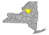
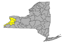
Genesee River Watershed
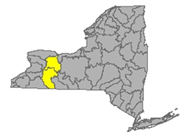
Genesee River originates in north-central Pennsylvania. The Genesee runs right through New York state, flowing generally north from the south state line up to Lake Ontario at Rochester. The watershed includes the following tributary flows, lakes and reservoirs: Conesus Lake, Silver Lake, Mount Morris Reservoir, Hemlock Lake, Honeoye Lake; Cassadaga Creek, Honeoye Creek, Oatka Creek, Black Creek
Flows parts of Monroe, Livingston, and Allegany Counties
- Genesee River drains an area of 2474 sq miles in Monroe, Livingston and Allegany Counties. The flow
- at Wellsville in Allegany County is below normal, 27.2% above mean at 57.2 cfs and 4.38 ft deep (flood stage 11 ft);
- at Portageville in Wyoming County is flowing normal, 24.8% above mean at 221 cfs and holding steady around 8.55 ft deep (flood stage 19ft);
- near Mount Morris in Livingston County is below normal, 23.8% above mean at 286 cfs and down half a foot, 2.6 ft deep;
- at Avon flow is below normal, 22.95% above mean at 318 cfs and down nearly three feet, 14.48 ft deep (flood stage 33 ft);
- flow is unrated at Ballantyne Bridge near Mortimer, 374 cfs and 11.8 ft deep;
- at Ford St. Bridge in Rochester, Monroe County, flow is much below normal, 18.15% above mean at 395 cfs and 12.83 ft deep, 24°C and 740 µS/cm. (updated 06-24-22)
- Allen Creek drains an area of 28.9 sq miles in Monroe County. The flow near Rochester flow is normal, 49.9% above mean at 12.4 cfs and 2.46 ft (updated 06-24-22)
- Honeoye Creek drains an area of 196 sq miles of Monroe County. The flow at Honeoye Falls in Monroe County is normal, 28% above mean at 19.7 cfs and down more than a foot, 2.35 ft deep (flood stage 6.5 ft) (updated 06-24-22)
- Conesus Creek drains an area of 72 sq miles in Livingston County. The flow is below normal near Lakeville in Livingston County, 28.5% above mean at 13 cfs and .62 ft deep. (updated 06-24-22)
- Canaseraga Creek drains an area of 88.9 sq miles of Livingston County. The flow
- above Dansville is below normal, 34.45% above mean at 17.1 cfs and .25 ft deep;
- at Shakers Crossing in Livingston County is normal, 33.1% above mean at 69.8 cfs and down inches this week, 3.68 ft deep. (updated 06-24-22)
- Keshequa Creek drains an area of 68.3 sq miles in Livingston County, flowing north to join the Genesee River. The flow at Sonyea is unrated, 41.05% above mean at half the flow volume, 10.9 cfs and .25 ft deep. (updated 06-24-22)
- Oatka Creek drains an area of 200 sq miles in Monroe County. The flow
- at Warsaw is normal, 24.6% above mean at 7.73 cfs and 3.09 ft deep;
- at Garbutt is below normal, 29.7% above mean at 52.3 cfs and 2.4 ft deep (flood stage 6ft). (updated 06-24-22)
- Black Creek drains an area of 130 sq miles in Monroe County. The flow at Churchville is normal: 18.8% above historic mean for this time of year, at 14.5 cfs and 1.5 ft deep, (flood stage 6ft,) (updated 06-24-22)
Impaired Water Bodies (23)
23 water bodies appear on the 2022 Draft 303(d) list for Genesee River Watershed, up from 11 in the last list. Of the 23 total, 6 are affected by a proposed delisting in 2022, in whole or in part.
For more details, check out the posted list under the NW tab.
Hazardous Algae Blooms – HABs (5)
- Silver Lake, small localized bloom confirmed June 24, location tag places this on the south beach in Silver Lake State Park. Reported by the public in Wyoming County.
- Honeoye Lake
- Large localized bloom confirmed June 30 appearing north of the west side point on the shore closest to Ranch Rd. Reported by Honeoye Lake Watershed Task Force in Ontario County.
- An open water bloom was confirmed June 30 in the middle of the water body. Reported by HLWTF.
- A widespread/lakewide bloom was confirmed June 21, appearing by location tag on the NYHABs map as west shore, south of Cratsley Hill Rd. This bloom was also reported by HLWTF.
- Six previous confirmed blooms this season have been archived.
- Avon Marsh Dam Pond, widespread/lakewide bloom confirmed June 28, the location tag has this in the centre of the water body. Reported by Dept of Environmental Conservation staff in Livingston County.
- Loon Lake, large localized bloom confirmed June 25. Reported by CSLAP in Steuben County.
Spills (10)
Livingston County:
-Equipment failure in Geneseo, on the 6000 block of Morris Rd, caused unknown amounts of mineral oil to be spilled. No material was recovered from the environment.
-Traffic accident in Lima, on Plank Rd, caused 5 gallons of diesel to be spilled. No material was recovered from the environment.
Monroe County:
-Other cause in Rochester, on the 2500 block of Monroe Ave, caused unknown amounts of gasoline to be spilled. No material was recovered from the environment.
-Other cause in Rochester, on the 0-100 block of Primrose St, caused unknown amounts of sulfuric acid to be spilled. No material was recovered from the environment.
-Equipment failure in Rochester, on the 100 block of south Ave, caused 75 gallons of diesel to be spilled. 40 gallons of material were recovered from the environment.
-Equipment failure in Rochester, on the 400 block of Elmwood Ave, caused unknown amounts of hydraulic oil to be spilled. No material was recovered from the environment.
-Equipment failure in Rochester, on the 1400 block of Clover St, caused unknown amounts of #2 fuel oil to be spilled. No material was recovered from the environment.
-Storm in Honeoye Falls, on the 300 block of Boughton Hill Rd, caused 5 gallons of mineral oil to be spilled. No material was recovered from the environment.
-Other cause in Henrietta, on the 2000 block of Brighton Henrietta Townline Rd, caused unknown amounts of other material to be spilled. No material was recovered from the environment.
Wyoming County:
-Equipment failure in Middlebury, caused unknown amounts of sodium chloride to be spilled. No material was recovered from the environment.
Oswego River and Finger Lakes Watershed
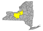
The Oswego River originates in the Adirondacks, with the combined flows of the Seneca River and many tributaries, drains a large area of northern New York to Lake Ontario. The water bodies found in this drainage basin include the Finger Lakes: Otisco, Skaneateles, Owasco, Cayuga, Oneida, Seneca, Keuka, Canandaigua and Canadice Lakes; Oneida River, Clyde River, Cayuga Lake Tributaries and Seneca Lake Tributaries
Flows draining parts of Oswego, Madison, Cayuga, Tompkins, Seneca, Onondaga, Yates and Ontario Counties
- Oswego River drains an area of 5100 sq miles of Oswego, Madison, Cayuga, Tompkins, Seneca, Onondaga, Yates and Ontario counties. The flow
- near Phoenix is not rated, 45.5% above historic mean at 2660 cfs and 3.01 ft deep;
- at Lock 7 in Oswego County is normal, 51.1% above mean at 2570 cfs and down a foot, 3.36 ft deep, 23.4°C and 814 µS/cm. (updated 06-24-22)
- Seneca River drains an area of 3130 sq miles of Onandaga County. The flow
- near Seneca Falls is unrated, 92.4% above mean at 526 cfs and 5.61 ft deep;
- at Free Bridge Corners is unrated, 20.1% above mean at 371 cfs and 5.66 ft deep;
- near Port Byron is unrated, 40.7% above mean at 1090 cfs and down a foot, 3.6 ft deep;
- near Baldwinsville in Onondaga County is below normal, 32.75% above mean, barely a quarter of last week’s volume, 900 cfs and 2.68 ft deep (updated 06-24-22)
- Ganaragua Creek drains an area of 115 sq miles in Wayne County before joining the Oswego River. The flow at Macedon is unrated, 65.4% above mean at 38.2 cfs and down half a foot, 2.08 ft deep. (updated 06-24-22)
- Canandaigua Outlet drains 195 sq miles of Ontario County. The flow at Chapin in Ontario County is much below normal, 15.8% above mean at 22.3 cfs and 3.27 ft deep (flood stage 7ft) (updated 06-24-22)
- Owasco Inlet drains an area of 106 sq miles in Cayuga County. The flow
- below Aurora St at Moravia is unrated 54.6% above mean flow at double the flow volume, 43.5 cfs and 1.91 ft deep;
- at Owasco Outlet at Genesee St Auburn is unrated, 38.2% above mean at 77.2 cfs and down three-quarters of a foot, 1.04 ft deep (flood stage 8 ft) (updated 06-24-22)
- Skaneateles Creek drains an area of 85.9 sq miles in Onandaga County. The flow at Skaneateles Junction is unrated, 22.8% above mean at 22.5 cfs and 1.92 ft deep. (updated 06-24-22)
- Flint Creek drains an area of 102 sq miles of Ontario County. The flow at Phelps in Ontario County is normal, 21.5% above mean at 18.9 cfs and down nearly half a foot, 1.34 ft deep. (updated 06-24-22)
- Keuka Lake drains an area of 207 sq miles in Yates County. At the outlet near Dresden in Yates County, the flow is below normal, 14.8% above mean at 23.6 cfs and 2.08 ft deep. (reading same as last week) (updated 06-24-22)
- Fish Creek drains an area of 403 sq miles in Oneida County. The flow at Becks Grove is unrated, 50.3% above mean at 499 cfs and 5.29 ft deep. (updated 06-24-22)
- East Branch Fish Creek drains 188 sq miles in Oneida County. The flow at Taberg is normal, 65.5% above mean at 185 cfs and down another half a foot, 4.51 ft deep. (updated 06-24-22)
- Oneida Creek drains an area of 113 sq miles in Oneida County. The flow at Oneida is normal, 48.2% above mean at 53.8 cfs and 2.06 ft deep (flood 11ft) (updated 06-24-22)
- Oneida River drains an area of 1349 sq miles of Oneida County. The flow near Euclid is unrated, 14.71% above mean at 293 cfs and 307 ft deep (updated 06-24-22)
- Scriba Creek drains an area of 38.4 sq miles in Oswego County. The flow at Constantia is unrated, 88.6% above mean at 31.3 cfs and down slightly again this week, 1.96 ft deep. (updated 06-24-22)
- Chittenango Creek drains an area of 66.3 miles of Madison County, flowing into Oneida Lake, into Oneida River and joining the Oswego River. The flow near Chittenango is unrated, 106.1% above historic mean at 57.6 cfs and 1.36 ft deep. (flood stage 6ft) (updated 06-24-22)
- Onandaga Creek drains an area of 110 sq miles of Onandaga County. The flow
- at Dorwin Ave in Syracuse is normal, 48.3% above mean at 45.2 cfs and down half a foot, 1.73 ft deep,
- at Spencer St in Syracuse is above normal, 64% above mean at 88.5 cfs and down over half a foot, 72 ft deep. (updated 06-24-22)
- Salmon Creek drains an area of 87.7 sq miles in Tompkins County. The flow at Ludlowville is unrated, 31.5% above mean at 18.6 cfs and .67 ft deep. (updated 06-24-22)
- Sixmile Creek drains an area of 39 sq miles in Tompkins County. Flow
- at Brooktondale is unrated, 53.1% above mean at 10.1 cfs and .45 ft deep;
- at Bethel Grove is unrated, 60.8% above mean at 21.8 cfs and .8 ft deep. (updated 06-24-22)
- Fall Creek drains an area of 126 sq miles of Tompkins County. The flow near Ithaca is normal, 28.5% above mean at 42.2 cfs and .74 ft deep (flood stage 6ft). (updated 06-24-22)
Impaired Water Bodies
40 water bodies appear on the 2022 Draft 303(d) list for Oswego River Watershed, up from 7 in the last list. Of the 40 total, 11 are affected by a proposed delisting in 2022, in whole or in part.
For more details, check out the posted list under the NW tab.
HABs (2)
- Song Lake, small localized bloom confirmed June 25 in Cortland County. Reported by CSLAP in Cortland County.
- Fairport Reservoir, large localized bloom confirmed June 23 at the north end of the western reservoir, close to the outlet into Sucker Brook. Reported by the public in Ontario County.
Spills (6)
Onondaga County:
-Unknown cause in Syracuse, on the 900 block of Blvd West, caused unknown amounts of unknown petroleum to be spilled. No material was recovered from the environment.
-Equipment failure in Syracuse, on the 0-100 block of Forestry Dr, caused unknown amounts of hydraulic oil to be spilled. No material was recovered from the environment.
-Equipment failure in Geddes, on the W I690 Mile 10.7, caused unknown amounts of gasoline to be spilled. No material recovered from the environment.
Tompkins County:
-Unknown cause in Ithaca, on the 815 South, caused unknown amounts of unknown petroleum to be spilled. No material was recovered from the environment.
Oneida County:
-Equipment failure in Utica, on the 1700 block of Tilden Ave, caused 5 gallons of hydraulic oil to be spilled. No material was recovered from the environment.
Oswego County:
-Equipment failure in Oswego, on the 448 ST Rt 1A, caused 4 gallons of hydraulic oil to be spilled. No material was recovered from the environment.
Southwest Watersheds
Allegheny: emptying into the Gulf of Mexico via Ohio River/Mississippi River; Chemung and Susquehanna emptying into the Atlantic Ocean via Chesapeake Bay
Allegheny River Watershed
(flowing west into Ohio River system)
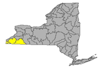
The Allegheny River originates in Pennsylvania, curving north to take a short loop through southwest New York and back down into PA. Tributaries to the Allegheny system include Chadakoin River, Conewango Creek, Cassadaga Creek, Olean Creek, Great Valley Creek, and French Creek. Important water bodies include the Allegheny Reservoir and popular recreational destination, Chautauqua Lake.
Flows taking in parts of Chautauqua and Cattaraugus County
- Chadakoin River drains an area of 194 sq miles of Chautauqua County. The flow at Falconer is below normal, 24.9% above mean at 50.1 cfs and --- ft deep (flood stage 4ft) (06-24-22)
- Allegheny River drains an area of 1608 sq miles of Cattaraugus County. The flow
- at Olean is unrated, 30.25% above mean at 452 cfs and up a few inches, 1.62 ft deep (flood stage 12 ft);
- at Salamanca is normal, 33.7% above mean at 762 cfs and 3.17 ft deep, (flood stage 12 ft) 18.2°C. (updated 06-24-22)
- Dodge Creek drains an area of 47.7 sq miles in Cattaraugus County. The flow at Portville is unrated, 4.6 ft deep (no change in four weeks, the sensor is likely malfunctioning) (updated 06-24-22)
Impaired Water Bodies (14)
14 water bodies appear on the 2022 Draft 303(d) list for Allegheny River Watershed, up from 8 in the last list. Of the 14 total, 2 are affected by a proposed delisting in 2022, in whole or in part.
For more details, check out the posted list under the SW tab.
HABs (3)
- Chautauqua Lake
- A small localized bloom was confirmed June 22 at the south end of the lake, reported by Chautauqua Lake Association.
- A small localized bloom was confirmed June 21 at Bemus Bay. Reported by Chautauqua Lake Association in Chautauqua County.
- Small localized bloom confirmed June 20 at Long Park Point Marina. Also reported by the lake association in Chautauqua County.
Spills (3)
Chautauqua County:
-Traffic accident in Frewsburg, on the 0-100 block of Falcon St, caused 2 gallons of transformer oil to be spilled. No material was recovered from the environment.
-Human error in Sinclairville, on Harvey Rd and RT 380, caused unknown amounts of grey and black water to be spilled. No material was recovered from the environment.
-Human error in Sinclairville, on the 6700 block of Cleland Rd, caused 2.5 gallons of hydraulic oil to be spilled. No material was recovered from the environment.
Chemung River Watershed
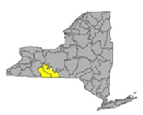
The Chemung River flows across the western portion of the Southern Tier of New York State before joining the Susquehanna River and eventually emptying into the Chesapeake Bay.
Including Chemung River, Cohocton River, Tioga River, Canisteo River; Lamoka Lake/Mill Pond, Waneta Lake, Almond Lake
Flows: washing over parts of Steuben and Chemung Counties
- Chemung River drains an area of 2506 sq miles in Steuben and Chemung Counties. The flow
- at Corning is normal, 39.3% above mean, 520 cfs and 15.04 ft deep (flood stage is 29ft);
- at Elmira in Chemung County, flow is unrated, 64.5% above mean at 612 cfs and 1.35 ft deep (flood stage 12 ft);
- at Chemung is normal, 25.6% above mean at 606 cfs and 3.3 ft deep. (flood stage 16 ft) (updated 06-24-22)
- Canisteo River drains an area of 40 sq miles of Steuben County. The flow
- at Arkport is much below normal, 6.7% above mean at 1.99 cfs and .68 ft deep;
- below Canacadea Creek at Hornell in Steuben County is below normal, 16.4% above mean at 27.6 cfs and .62 ft deep (flood stage 9ft);
- at West Cameron in Steuben County much below normal, 15.5% above mean at 32.4 cfs and 3.57 ft deep (flood stage 17ft). (updated 06-24-22)
- Canacadea Creek drains an area of 57.9 sq miles in Steuben County. The flow near Hornell is below normal, 11.73% above historic mean at 9.59 cfs and down half a foot, .9 ft deep. (flood stage 5ft)(updated 06-24-22)
- Cohocton River drains an area of 370 sq miles of Steuben County. The flow
- near Avoca is unrated, 33.4% above mean at 36.1 cfs and 2.41 ft deep (flood stage 9ft);
- at Bath is 2.41 ft deep (flood stage 11ft);
- near Campbell in Steuben County is below normal, 22.9% above mean at half last week’s volume, 84 cfs and down to 2.31 ft deep (flood stage 10ft). (updated 06-24-22)
- Tuscarora Creek drains an area of 102 sq miles sq miles in Steuben County before joining the Tioga River, flowing north to the Chemung system. The flow above South Addison is unrated, 18.2% above mean at one-third the flow volume of last week, 6.21 cfs and .15 ft deep. (flood stage 9 ft) (updated 06-24-22)
- Tioga River drains an area of 1377 sq miles in Steuben County. The flow at headwaters in PA,
- at Tioga Junction, PA is above normal, 80.45% above mean at four times the flow volume of last week, 253 cfs and up over half a foot deeper, 7.32 ft deep, 21.9ºC and 203 µS/cm;
- at Lindley, NY is normal, 40% above mean at 252 cfs and up half a foot, 3.7 ft deep;
- near Erwins is normal, 41.5% above mean at 383 cfs and up nearly half a foot, 1.22 ft deep (flood stage 18ft); (updated 06-24-22)
Impaired Water Bodies (9)
9 water bodies appear on the 2022 Draft 303(d) list for Chemung River Watershed, up from one in the previous list. Of the 9 total, 2 are affected by a proposed delisting in 2022, in whole or in part.
For more details, check out the posted list under the SW tab.
HABs (2)
- Loon Lake, two large localized blooms confirmed June 22 and June 25. The location pin indicates both blooms are in the centre of the water body. Reported by CSLAP in Steuben County.
Spills (3)
Chemung County:
-Equipment failure in Horseheads, on the 0-100 block of South Cemetery, caused 3 gallons of antifreeze to be spilled. No material was recovered from the environment.
Steuben County:
-Unknown cause in Bath caused unknown amounts of unknown material to be spilled. No material was recovered from the environment.
-Traffic accident in Avoca, on 8654 CR-105, caused 7 gallons of transformer oil to be spilled. No material was recovered from the environment.
Susquehanna River Watershed
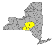
The Susquehanna River drains 27,500 square miles covering large parts of New York, Pennsylvania and Maryland before emptying into the Chesapeake Bay. The flow begins in south New York State and flows in a westerly direction close to the south state line before departing into PA.
Including: Chenango River, Tioughnioga River, Unadilla River, Owego Creek; Otsego Lake, Canadarago Lake, Whitney Point Lake/Reservoir
Flows parts of Otsego, Broome, Chenango and Cortland Counties
- Susquehanna River drains an area of 4773 sq miles of Otsego and Broome Counties, flows from its headwaters at Otsego Lake in a south-westerly direction, crossing the border into Pennsylvania near Waverly NY. The flow
- at Unadilla is above normal, 181.1% above mean at 1510 cfs and up a foot and a half from last week, 4.28 (flood stage 11 ft) ft deep;
- at Bainbridge is unrated, 81.25% above mean at double last week’s volume, 1710 cfs and up more than a foot, 3.01 ft deep (flood stage 15 ft);
- at Windsor, unrated, 52.2% above mean at 1360 cfs and up half a foot, 3.97 ft deep (flood stage 17ft);
- at Conklin flow is normal, 58.25% above mean at 1280 cfs and holding around 3.18 ft deep (flood stage 12 ft);
- at Binghamton, the flow is not rated, holding steady around 2.67 ft deep, (flood stage 14 ft);
- at Vestal in Broome County is normal, 60.8% above mean at 2010 cfs and down inches, 3.51 ft deep (flood stage 18 ft);
- at Owego is unrated, 44.3% above mean is 2130 cfs and 14.02 ft deep (flood stage 30 ft);
- at Waverly flow is normal, 40.9% above mean at 2230 cfs and down half a foot, 1.79 ft deep (flood stage 13 ft). (updated 06-24-22)
- Owego Creek drains an area of 185 sq miles in Tioga County. The flow near Owego is unrated, 59.7% above mean, 85 cfs and .96 ft deep (flood stage 9ft) (updated 06-24-22)
- Chenango River drains an area of 1483 sq miles in Broome and Chenango Counties. The flow
- at Sherburne is normal, 41% above mean at 93.6 cfs and 1.88 ft deep (flood stage 8.5 ft);
- at Oxford in Chenango is unrated, 34.1% above mean at 213 cfs and holding steady at 7.51 ft deep;
- at Greene in Chenango County flow is normal, 52.2% above mean at 250 cfs and holding steady depth around 2.37 ft deep;
- at Chenango Forks in Broome County is normal, 33.4% above mean at 536 cfs and down inches, 2.89 ft deep (flood stage 10ft). (updated 06-24-22)
- Tioughnioga River drains an area of 292 sq miles in Cortland County. The flow
- at Cortland is normal, 38.7% above mean at 144 cfs and 3.12 ft deep;
- at Itaska the flow is not rated, down almost half a foot from last week, 1.37 ft deep (flood stage 7 ft). (updated 06-24-22)
- Otselic River drains an area of 147 sq miles in Cortland County. The flow at Cincinnatus is normal, 52.8% above mean at 66.8 cfs and .8 ft deep (flood stage 9 ft) (updated 06-19-22)
- Unadilla River drains an area of 520 sq miles of Chenango County. The flow at Rockdale is normal, 63.4% above mean at 343 cfs and three inches lower, 4.73 ft deep (flood stage 11 ft). (updated 06-12-22)
- Ouleout Creek drains an area of 103 sq miles in Delaware County. The flow at East Sydney is much above normal, 511% above mean at more than ten times the flow volume of last week, 443 cfs and up over a foot, 2.46 ft deep (flood stage 4.5 ft) (updated 06-24-22)
Impaired Water Bodies (18)
18 water bodies appear on the 2022 Draft 303(d) list for Susquehanna River Watershed, up from three in the last listing. For more details, check out the posted list under the SW tab.
Hazardous Algae Blooms (HABs)
- Bradley Brook Reservoir, small localized bloom confirmed on June 29 in Madison County. Reported by the Citizens Statewide Lake Assessment Program. The location tag on NYHABs suggests this bloom is located in the middle of the lake. The photo attached with the report shows a bloom resembling spilled paint at the shoreline.
Bradley Brook Reservoir June 29, 2022, report submitted to NYHABS by CSLAP
Spills (2)
Broome County:
-Unknown cause in Endicott, on the 100 block of Lincoln Ave, caused unknown amounts of unknown material to be spilled. No material was recovered from the environment.
-Other cause in Endicott, on the 3100 block of Watson Blvd, caused unknown amounts of #2 fuel oil to be spilled. No material was recovered from the environment.
Ramapo River Watershed
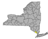
The northern headwaters of the Passaic basin lie within a small portion of southeastern New York State, including the Ramapo and Hackensack Rivers drainage areas, flowing south through New Jersey with outlet into the Atlantic at Chesapeake Bay. Including Ramapo River, Hackensack River, Greenwood Lake, and DeForest Lake.
Flows: concerned with parts of Rockland and Orange Counties
- Mahwah River drains an area of 12 sq miles in Rockland. The flow near Suffern is normal, 33.5% above historical mean at 7.34 cfs and 1.69 feet deep (flood stage 5ft) (updated 06-23-22)
- Ramapo River drains an area of 93 sq miles in Rockland County. The flow
- at Ramapo is normal, 26.3% above mean at 28.4 cfs and 1.81 ft deep (flood stage is 10 ft);
- near Mahwah NJ is normal, 69.2% above mean at 97.8 cfs and 3.04 ft deep (flood stage 8ft);
- at Suffern, normal, 34.8% above mean, 38.2 cfs and down, 2.19 ft deep (flood stage is 15.2ft) (updated 06-23-22)
- Hackensack River drains an area of 30.7 sq miles in Rockland County. The flow at West Nyack is below normal, 26.3% above historical mean flow at 11.9 cfs and down a foot and a half, 2.56 ft deep. (updated 06-23-22)
Impaired Water Bodies (14)
14 Water bodies appear on the Draft 303(d) list for Ramapo River watershed in 2022, with 5 proposed for delisting, in whole or in part.
For more details, check out the posted list under the Ramapo tab.
HABs (0)
- A bloom reported in May has been archived.
Spills (4)
Rockland County:
-Equipment failure in New City, on 0-100 block of Fairhaven Dr, caused 2 gallons of transformer oil to be spilled. No material was recovered from the environment.
-Equipment failure in Haverstraw, on RT 202, caused 10 gallons of other material to be spilled. No material was recovered from the environment.
-Unknown cause in Haverstraw, on RT 202, caused unknown amounts of raw sewage to be spilled. No material was recovered from the environment.
-Unknown cause in Nyack, on Hudson Ave, caused unknown amounts of concrete to be spilled. No material was recovered from the environment.
Report Key:
Flows: USGS Monitoring stations vary in the amount of data collected, certain stations report flow depth and flood stage only, the majority of stations included in this report show the variability of the flow, with a rating of low, normal, above normal, much above normal or high.
Water quality parameters are detected at certain sites, including temperature (°C) and specific conductance (µS/cm). Specific conductance is an important measurement of water quality. This is a measure of the way that electrical current moves through the water; any change in this number is an early warning of changing contaminant loads. The measurement taken by USGS is temperature adjusted to 25°C, allowing for comparison of the specific value from week to week.
National Weather Service: high water terminology here https://www.weather.gov/aprfc/terminology
Impaired Water Bodies (these are lakes, reservoirs, rivers, or parts of rivers with water quality tests indicating the system is impaired; these are listed in New York State 2018 Final Section 303 (d) list, along with the contaminant of concern and the suspected source of contamination. The NYS DEC recommends the water body for a Total Maximum Daily Load (TMDL) watershed protection plan.
Spills Report– hazardous materials spill incidents by county, as appearing in the NYS Environmental Sites - Spill Incidents Database, from week to week as records are uploaded.
See Watershed Basics Glossary for more details.
|